
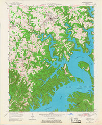
1953 Map of Jamestown
USGS Topo · Published 1955About this map
Jamestown and its surrounding ridge-top communities sit overlooking the intricate, branching fingers of Lake Cumberland in the early 1950s. This survey, completed shortly after the reservoir reached its full pool, shows a landscape in transition where old upland roads now terminate at the water's edge. Local life is anchored by small rural centers like Sewellton, Freedom, and Rose Crossroads, with family landmarks such as Murray Cem and Lawless Cem preserved on the high ground. Educational and spiritual needs are reflected in the scattered sites of the Worldridge Sch and Belle Chapel. Along the new shoreline, emerging recreational facilities like the State Dock and Pleasant Hill Dock signal the region's shift toward a lake-based economy, while the Lake Cumberland State Park boundary follows the 760-foot contour through the deep hollows of Greasy Creek and Lily Creek.
Find a feature on this map
48 named features on this map. Tap any name to fly to it.
Don’t see what you’re looking for? This feature index may not catch every label — zoom into the map to look around manually.
Map Details
Editions of this 1953 Jamestown Map
2 editions found
Other maps of this area

1911 · Monticello
USGS Topo · 1:62,500

1914 · Monticello
USGS Topo · 1:62,500

1953 · Montpelier
USGS Topo · 1:24,000

1953 · Parnell
USGS Topo · 1:24,000

1953 · Wolf Creek Dam
USGS Topo · 1:24,000

1953 · Creelsboro
USGS Topo · 1:24,000

1954 · Jabez
USGS Topo · 1:24,000

1954 · Cumberland City
USGS Topo · 1:24,000

1954 · Russell Springs
USGS Topo · 1:24,000

1954 · Eli
USGS Topo · 1:24,000