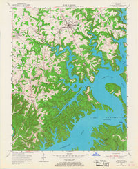
1953 Map of Jamestown
USGS Topo · Published 1967About this map
Jamestown and its surrounding hill country are defined here by the winding, branched expanse of Lake Cumberland, a landscape transformed by the impoundment of the Cumberland River. The map documents the area during a period of transition as the newly created shoreline of Lake Cumberland State Park became a focal point for recreation, evidenced by Jamestown Dock and State Dock. Inland, the traditional agricultural and social fabric of Russell County remains visible through a network of small settlements and community landmarks. Researchers can identify numerous rural institutions such as Moores Sch, Wooldridge Sch, and local congregations at Concord Ch and Belle Chapel. The irregular fingers of the lake reach deep into former valleys like Lily Creek and Greasy Creek, illustrating how the controlled inundation reshaped local geography while preserving the upland road networks like KY 35 and KY 92.
Find a feature on this map
59 named features on this map. Tap any name to fly to it.
Don’t see what you’re looking for? This feature index may not catch every label — zoom into the map to look around manually.
Map Details
Editions of this 1953 Jamestown Map
2 editions found
Other maps of this area

1911 · Monticello
USGS Topo · 1:62,500

1914 · Monticello
USGS Topo · 1:62,500

1953 · Montpelier
USGS Topo · 1:24,000

1953 · Parnell
USGS Topo · 1:24,000

1953 · Wolf Creek Dam
USGS Topo · 1:24,000

1953 · Creelsboro
USGS Topo · 1:24,000

1953 · Jamestown
USGS Topo · 1:24,000

1954 · Jabez
USGS Topo · 1:24,000

1954 · Cumberland City
USGS Topo · 1:24,000

1954 · Russell Springs
USGS Topo · 1:24,000