1950s Maps of Green Lane Garden, Scott County
Explore 6 historic maps of Green Lane Garden from the 1950s. These maps offer a rare glimpse into what life looked like during the 1950s — showing old roads, neighborhoods, homes, and landmarks that have changed or disappeared over time.
Whether you're researching your family's past, planning a metal detecting trip, or studying how Green Lane Garden's landscape evolved across the 1950s, these high-resolution maps are a powerful tool for exploring the history of this region.
- Focus on a specific era: All maps on this page are from the 1950s, giving you a focused view of this time period.
- See what’s changed: Compare century-old streets, trails, and buildings to today's modern landscape using overlays and satellite layers.
- Research with precision: Use these maps for genealogy, historical research, land use analysis, or educational projects.
- View, download, or print: Maps are fully viewable online in high resolution, and can be downloaded or printed for your own records.
Start exploring Green Lane Garden's history through authentic maps from the 1950s. This is your window into the past.
Green Lane Garden, Scott County maps
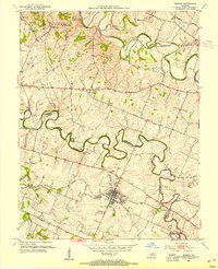
(6)- 1952 Map of Midway, 1955 Print
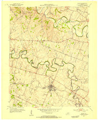 1952 Midway1955 Print · USGSMidway and the surrounding Bluegrass countryside are captured here in the early fifties as the Louisville and Nashville rail line still pulsed through the town center. Researchers can trace the exact locations of Spring Station, the Orphans Sch, and St Francis Mission amidst the winding creeks.
 - 1953 Map of Stamping Ground, 1955 Print
 1953 Stamping Ground1955 Print · USGSThe rural landscape of Scott and Owen counties in the early fifties is defined by small crossroads hamlets and the path of the Frankfort and Cincinnati railroad. Genealogists can trace family footprints through several local burial sites including Minorsville Cem, Riddle Cem, and Cedar Grove Cem.3 unique versions available
 - 1953 Map of Delaplain, 1955 Print
 1953 Delaplain1955 Print · USGSScott County in the early fifties is captured here as a network of ridge-top roads and creek-side hamlets. Genealogists and historians can trace family locations near Oxford, Salem Ch, or the County Farm along the Southern rail line.
 - 1954 Map of Midway, 1955 Print
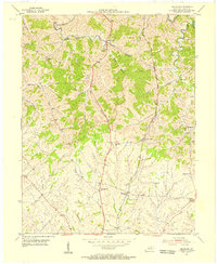
 1954 Midway1955 Print · USGSMid-century Woodford and Scott Counties are captured here as a landscape of rail-connected towns and winding creek valleys. Genealogists and researchers can trace local landmarks like the Orphans Sch, the St Francis Mission, and the crossroads at White Sulphur.4 unique versions available
 - 1954 Map of Georgetown, 1955 Print
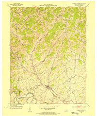
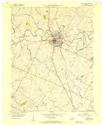 1954 Georgetown1955 Print · USGSScott County enters the mid-fifties as a hub of education and transport centered on the crossing of major rail lines and the winding Elkhorn Creek. Researchers can trace the grounds of Georgetown College, locate Paynes Depot, or find rural landmarks like Bethel Ch and Cardome Academy.
 - 1956 Map of Louisville, 1971 Print
 1956 Louisville1971 Print · USGSThe Ohio River valley and the Kentucky Bluegrass are captured here during a period of rapid mid-century growth and industrial activity. Genealogists and historians can trace rail-centered towns and military land use at Fort Knox and the Jefferson Proving Ground.2 unique versions available
End of results
Showing maps 1-6 of 6
Frequently asked questions
- What are the different types of historical maps available for Green Lane Garden?
- What is the oldest map of Green Lane Garden?
- Where can I purchase historical maps of Green Lane Garden for my home or office?
- Where can I download high-res historical maps of Green Lane Garden?
- Are there historical topographic maps available for Green Lane Garden?
- Is there historical aerial imagery available for Green Lane Garden?
- Where are historical maps of Green Lane Garden sourced from?