1970s Maps of Taylor County, Kentucky
Explore 3 historic maps of Taylor County from the 1970s. These maps offer a rare glimpse into what life looked like during the 1970s — showing old roads, neighborhoods, homes, and landmarks that have changed or disappeared over time.
Whether you're researching your family's past, planning a metal detecting trip, or studying how Taylor County's landscape evolved across the 1970s, these high-resolution maps are a powerful tool for exploring the history of this region.
- Focus on a specific era: All maps on this page are from the 1970s, giving you a focused view of this time period.
- See what’s changed: Compare century-old streets, trails, and buildings to today's modern landscape using overlays and satellite layers.
- Research with precision: Use these maps for genealogy, historical research, land use analysis, or educational projects.
- View, download, or print: Maps are fully viewable online in high resolution, and can be downloaded or printed for your own records.
Start exploring Taylor County's history through authentic maps from the 1970s. This is your window into the past.
Taylor County, KY maps
(3)- 1970 Map of Campbellsville, 1972 Print
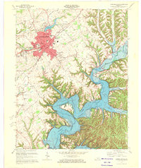 1970 Campbellsville1972 Print · USGSCampbellsville and the newly formed Green River Lake are captured in the early seventies during a period of significant regional growth. Local researchers can trace the development of Campbellsville College and locate rural landmarks like Shady Grove Ch and Durham Sch.3 unique versions available
 - 1970 Map of Cane Valley, 1972 Print
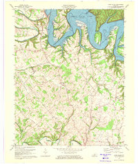 1970 Cane Valley1972 Print · USGSAdair and Green counties are captured here in the early seventies, a period defined by the sprawling waters of Green River Lake. Researchers can locate historic family burial sites like Green River Hill Confederate Cem and rural crossroads like Cane Valley and Coburg.4 unique versions available
 - 1970 Map of Mannsville, 1972 Print
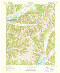 1970 Mannsville1972 Print · USGSTaylor County settlement meets the rising waters of the Green River reservoir in the 1970s. Genealogists can trace family connections at Christie Chapel, Eastridge Cem, and the small community of Feathersburg tucked between the ridges.
End of results
Showing maps 1-3 of 3
Top cities of Taylor County
Frequently asked questions
- What are the different types of historical maps available for Taylor County?
- What is the oldest map of Taylor County?
- Where can I purchase historical maps of Taylor County for my home or office?
- Where can I download high-res historical maps of Taylor County?
- Are there historical topographic maps available for Taylor County?
- Is there historical aerial imagery available for Taylor County?
- Where are historical maps of Taylor County sourced from?