1970s Maps of Cadiz, Kentucky
Explore 2 historic maps of Cadiz from the 1970s. These maps offer a rare glimpse into what life looked like during the 1970s — showing old roads, neighborhoods, homes, and landmarks that have changed or disappeared over time.
Whether you're researching your family's past, planning a metal detecting trip, or studying how Cadiz's landscape evolved across the 1970s, these high-resolution maps are a powerful tool for exploring the history of this region.
- Focus on a specific era: All maps on this page are from the 1970s, giving you a focused view of this time period.
- See what’s changed: Compare century-old streets, trails, and buildings to today's modern landscape using overlays and satellite layers.
- Research with precision: Use these maps for genealogy, historical research, land use analysis, or educational projects.
- View, download, or print: Maps are fully viewable online in high resolution, and can be downloaded or printed for your own records.
Start exploring Cadiz's history through authentic maps from the 1970s. This is your window into the past.
Cadiz, KY maps
(2)- 1974 Map of Gracey, 1976 Print
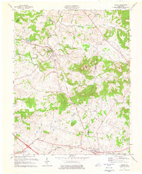 1974 Gracey1976 Print · USGSAcross the rolling borderlands of Trigg and Christian counties in the mid-1970s, this survey documents a network of small rail-side settlements and rural family cemeteries. Genealogists can locate family landmarks such as Ladd Cem and Montgomery Ch alongside the Illinois Central Gulf tracks.
 - 1974 Map of Caledonia, 1977 Print
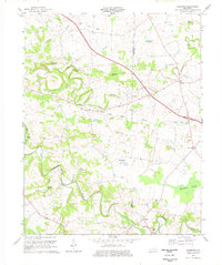 1974 Caledonia1977 Print · USGSTrigg and Christian counties in the mid-1970s reveal a landscape of rural hamlets and family farmsteads along the Little River. Genealogists can trace family names at the Old Presbyterian Cem and Bacon Cem, or locate historic sites like Binns Mill.2 unique versions available
End of results
Showing maps 1-2 of 2
Top cities near Cadiz
Top neighborhoods of Cadiz
Frequently asked questions
- What are the different types of historical maps available for Cadiz?
- What is the oldest map of Cadiz?
- Where can I purchase historical maps of Cadiz for my home or office?
- Where can I download high-res historical maps of Cadiz?
- Are there historical topographic maps available for Cadiz?
- Is there historical aerial imagery available for Cadiz?
- Where are historical maps of Cadiz sourced from?