1960s Maps of Sturgis, Kentucky
Explore 4 historic maps of Sturgis from the 1960s. These maps offer a rare glimpse into what life looked like during the 1960s — showing old roads, neighborhoods, homes, and landmarks that have changed or disappeared over time.
Whether you're researching your family's past, planning a metal detecting trip, or studying how Sturgis's landscape evolved across the 1960s, these high-resolution maps are a powerful tool for exploring the history of this region.
- Focus on a specific era: All maps on this page are from the 1960s, giving you a focused view of this time period.
- See what’s changed: Compare century-old streets, trails, and buildings to today's modern landscape using overlays and satellite layers.
- Research with precision: Use these maps for genealogy, historical research, land use analysis, or educational projects.
- View, download, or print: Maps are fully viewable online in high resolution, and can be downloaded or printed for your own records.
Start exploring Sturgis's history through authentic maps from the 1960s. This is your window into the past.
Sturgis, KY maps
(4)- 1961 Map of Evansville
 1961 Evansville1961 Print · USGSThe Ohio River valley and its surrounding coalfields are captured here during the late fifties and early sixties. Trace the industrial rail networks of the Illinois Central RR and explore regional landmarks like Mammoth Cave National Park and Angel Mounds State Memorial.2 unique versions available
 - 1961 Map of Paducah
 1961 Paducah1961 Print · USGSThe Lower Ohio Valley at mid-century is a landscape defined by its great rivers and newly formed reservoirs. Researchers can trace the riverfronts of Paducah and Metropolis, or locate smaller settlements like Old Shawneetown and Cave in Rock along the banks.2 unique versions available
 - 1964 Map of Paducah
 1964 Paducah1964 Print · USGSThe river-and-rail corridor of Southern Illinois and Western Kentucky is captured here during the height of the mid-century industrial era. Genealogists and researchers can trace local landmarks across several counties, from the rail yards of Paducah to the waters of Crab Orchard Lake and Kentucky Reservoir.2 unique versions available
 - 1969 Map of Sturgis, 1970 Print
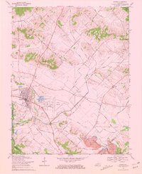 1969 Sturgis1970 Print · USGSUnion County and the Sturgis area are captured here in the late sixties, showcasing a landscape defined by coal mining and rural community life. Genealogists can locate family landmarks like Pythian Ridge Cem, Waller School, and the community of Pride.2 unique versions available
End of results
Showing maps 1-4 of 4
Top cities near Sturgis
- Providence historical maps
- Morganfield historical maps
- Marion historical maps
- Clay historical maps
- Shawneetown historical maps
- Uniontown historical maps
See more
Frequently asked questions
- What are the different types of historical maps available for Sturgis?
- What is the oldest map of Sturgis?
- Where can I purchase historical maps of Sturgis for my home or office?
- Where can I download high-res historical maps of Sturgis?
- Are there historical topographic maps available for Sturgis?
- Is there historical aerial imagery available for Sturgis?
- Where are historical maps of Sturgis sourced from?