1900s (20th Century) Maps of Uniontown, Kentucky
Explore 9 historic maps of Uniontown from the 1900s (20th Century). These maps offer a rare glimpse into what life looked like during the 1900s — showing old roads, neighborhoods, homes, and landmarks that have changed or disappeared over time.
Whether you're researching your family's past, planning a metal detecting trip, or studying how Uniontown's landscape evolved across the 1900s, these high-resolution maps are a powerful tool for exploring the history of this region.
- Focus on a specific era: All maps on this page are from the 1900s, giving you a focused view of this time period.
- See what’s changed: Compare century-old streets, trails, and buildings to today's modern landscape using overlays and satellite layers.
- Research with precision: Use these maps for genealogy, historical research, land use analysis, or educational projects.
- View, download, or print: Maps are fully viewable online in high resolution, and can be downloaded or printed for your own records.
Start exploring Uniontown's history through authentic maps from the 1900s. This is your window into the past.
Uniontown, KY maps
(9)- 1917 Map of Uniontown
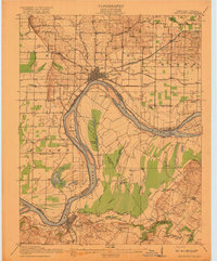 1917 Uniontown1917 Print · USGSThe Ohio River borderlands between Kentucky and Indiana were bustling with river and rail activity during the First World War. Local historians can trace dozens of rural school sites like Bethlehem School and river landmarks such as Slim Island and Hovey Lake.6 unique versions available
 - 1952 Map of Uniontown, 1954 Print
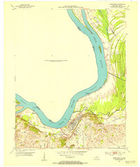 1952 Uniontown1954 Print · USGSUniontown and the surrounding river bottomlands are captured here in the early 1950s at a time of active petroleum extraction. Researchers can locate St Agnes Ch, trace the old Ferry crossing, and identify numerous Oil Wells across the landscape.2 unique versions available
 - 1954 Map of Evansville
 1954 Evansville1954 Print · USGSThe Ohio River borderlands between Indiana and Kentucky appear here during a period of robust industrial and military growth. Genealogists and researchers can trace the rail corridors of the Illinois Central and find landmarks like US Lock and Dam No 48 or Camp Breckinridge.
 - 1957 Map of Evansville, 1969 Print
 1957 Evansville1969 Print · USGSIndiana and Kentucky meet along the Ohio River in this mid-century survey of a vital industrial and transport corridor. Genealogists and historians can trace the development of river towns like Owensboro and Newburgh or locate old rail lines like the Southern Ry.3 unique versions available
 - 1958 Map of Uniontown, 1959 Print
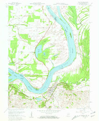 1958 Uniontown1959 Print · USGSThe Ohio River bend at the Kentucky-Indiana border comes alive in this late-fifties survey, showing a landscape of river navigation and oil extraction. Researchers can locate the Uniontown Cem, the Illinois Central rail line, and historic river markers like Dam No 49 (Mile 845).2 unique versions available
 - 1961 Map of Evansville
 1961 Evansville1961 Print · USGSThe Ohio River valley and its surrounding coalfields are captured here during the late fifties and early sixties. Trace the industrial rail networks of the Illinois Central RR and explore regional landmarks like Mammoth Cave National Park and Angel Mounds State Memorial.2 unique versions available
 - 1981 Map of Uniontown
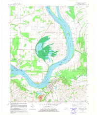 1981 Uniontown1981 Print · USGSThe riverfront town of Uniontown and its surrounding floodplains are captured here in the early eighties as a landscape of managed wetlands and river industry. Researchers can trace the river's path through Mississippi Bend or locate local landmarks like St Agnes Cem and the Uniontown Locks and Dam.
 - 1986 Map of Evansville
 1986 Evansville1986 Print · USGSThe Ohio River valley thrives in the mid-1980s as a hub of river commerce, industry, and natural preservation spanning the Indiana-Kentucky border. Genealogists and historians can locate remote landmarks like Dead Mans Cem, Lippe Church, and the riverside community of Scuffletown.
 - 1991 Map of Evansville
 1991 Evansville1991 Print · USGSThe tri-state region of Indiana and Kentucky was a hub of river commerce and rail transport in the early nineties. Researchers can trace the industrial corridor between Evansville and Owensboro, locating landmarks like Angel Mounds State Memorial and the Seaboard System railroad.
End of results
Showing maps 1-9 of 9
Top cities near Uniontown
- Mount Vernon historical maps
- Morganfield historical maps
- Sturgis historical maps
- Corydon historical maps
- Emma historical maps
- New Haven historical maps
See more
Frequently asked questions
- What are the different types of historical maps available for Uniontown?
- What is the oldest map of Uniontown?
- Where can I purchase historical maps of Uniontown for my home or office?
- Where can I download high-res historical maps of Uniontown?
- Are there historical topographic maps available for Uniontown?
- Is there historical aerial imagery available for Uniontown?
- Where are historical maps of Uniontown sourced from?