1900s (20th Century) Maps of Upton, Kentucky
Explore 8 historic maps of Upton from the 1900s (20th Century). These maps offer a rare glimpse into what life looked like during the 1900s — showing old roads, neighborhoods, homes, and landmarks that have changed or disappeared over time.
Whether you're researching your family's past, planning a metal detecting trip, or studying how Upton's landscape evolved across the 1900s, these high-resolution maps are a powerful tool for exploring the history of this region.
- Focus on a specific era: All maps on this page are from the 1900s, giving you a focused view of this time period.
- See what’s changed: Compare century-old streets, trails, and buildings to today's modern landscape using overlays and satellite layers.
- Research with precision: Use these maps for genealogy, historical research, land use analysis, or educational projects.
- View, download, or print: Maps are fully viewable online in high resolution, and can be downloaded or printed for your own records.
Start exploring Upton's history through authentic maps from the 1900s. This is your window into the past.
Upton, KY maps
(8)- 1934 Map of Munfordville
 1934 Munfordville1934 Print · USGSHart County communities line the corridor of the Green River and the Nashville Road during the mid-1930s. Genealogists can trace family footprints through dozens of local landmarks like Poundstone Roller Mill, Big Springs Cem, and Priceville.
 - 1937 Map of Munfordville
 1937 Munfordville1937 Print · USGSThe Green River valley in the 1930s was a landscape of river fords and knob-country schools. Genealogists can trace family footprints across dozens of local sites like Falling Springs Ch, Big Springs Cem, and the old Rider Mill.
 - 1954 Map of Upton, 1955 Print
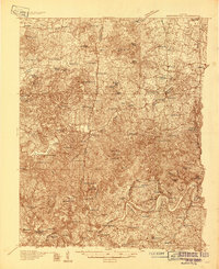
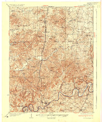
 1954 Upton1955 Print · USGSCentered on the Hardin and Hart county line in the mid-fifties, this area shows a landscape of rail-linked towns and karst springs. Researchers can trace family history through sites like Lucas Grove Ch, Upton Cem, and the old mill at Riders Mill.
 - 1957 Map of Winchester, 1968 Print
 1957 Winchester1968 Print · USGSCentral Kentucky's landscape in the mid-twentieth century features the sprawling Fort Knox and the early parkway system. Genealogists and historians can trace rail lines like the Southern Railway and find landmarks from Bernheim Forest to Pilot Knob.3 unique versions available
 - 1960 Map of Winchester
 1960 Winchester1960 Print · USGSCentral Kentucky's diverse landscape is shown here at mid-century, from the bluegrass plains to the rugged Pottsville Escarpment. Genealogists and historians can trace the rail-and-river network connecting towns like Bardstown and Stanford alongside landmarks like Lake Cumberland.
 - 1967 Map of Upton, 1969 Print
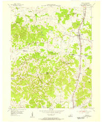
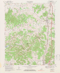
 1967 Upton1969 Print · USGSUpton and Bonnieville are captured in the late sixties along the Louisville and Nashville rail line. Genealogy researchers can trace family landmarks and rural hubs like Lone Star, Riders Mill, and Stoney Point Ch.2 unique versions available
 - 1979 Map of Upton, 1984 Print
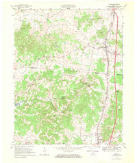
 1979 Upton1984 Print · USGSThe Kentucky rail-and-road corridor between Hardin and Hart Counties is captured here during the late seventies. Researchers can trace rural life through sites like Riders Mill, the Louisville and Nashville railroad, and dozens of family cemeteries like Brashear Cem.
 - 1986 Map of Campbellsville
 1986 Campbellsville1986 Print · USGSCentral Kentucky in the mid-eighties was a landscape of deep river valleys and high ridges. Genealogists can trace family holdings near rural settlements like Phillipsburg or locate landmarks such as Mt Gilead Ch and the Magnolia Gas Storage Field.2 unique versions available
End of results
Showing maps 1-8 of 8
Top cities near Upton
- Elizabethtown historical maps
- Hodgenville historical maps
- Munfordville historical maps
- Bonnieville historical maps
- Sonora historical maps
Frequently asked questions
- What are the different types of historical maps available for Upton?
- What is the oldest map of Upton?
- Where can I purchase historical maps of Upton for my home or office?
- Where can I download high-res historical maps of Upton?
- Are there historical topographic maps available for Upton?
- Is there historical aerial imagery available for Upton?
- Where are historical maps of Upton sourced from?