1970s Maps of Washington County, Kentucky
Explore 5 historic maps of Washington County from the 1970s. These maps offer a rare glimpse into what life looked like during the 1970s — showing old roads, neighborhoods, homes, and landmarks that have changed or disappeared over time.
Whether you're researching your family's past, planning a metal detecting trip, or studying how Washington County's landscape evolved across the 1970s, these high-resolution maps are a powerful tool for exploring the history of this region.
- Focus on a specific era: All maps on this page are from the 1970s, giving you a focused view of this time period.
- See what’s changed: Compare century-old streets, trails, and buildings to today's modern landscape using overlays and satellite layers.
- Research with precision: Use these maps for genealogy, historical research, land use analysis, or educational projects.
- View, download, or print: Maps are fully viewable online in high resolution, and can be downloaded or printed for your own records.
Start exploring Washington County's history through authentic maps from the 1970s. This is your window into the past.
Washington County, KY maps
(5)- 1972 Map of Ashbrook, 1973 Print
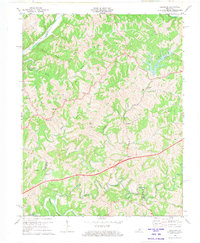 1972 Ashbrook1973 Print · USGSAnderson and Washington counties are captured here in the early 1970s as the Blue Grass Parkway reshaped the rural landscape. Researchers can trace historic local hubs like Ashbrook, Sinai, and Johnsonville alongside old schools like Western Sch.3 unique versions available
 - 1972 Map of Springfield, 1973 Print
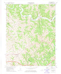
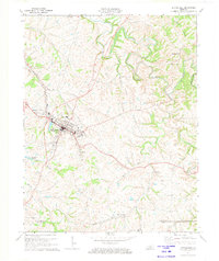 1972 Springfield1973 Print · USGSSpringfield and the Washington County countryside are captured in the early seventies as the local rail and road networks matured. Researchers can trace family-named settlements like Briartown and Jimtown, or locate local landmarks such as St Rose Ch and Lincoln Homestead State Park.2 unique versions available
 - 1972 Map of Maud, 1973 Print
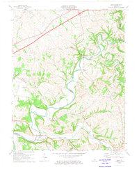 1972 Maud1973 Print · USGSWashington and Nelson Counties are shown in the early seventies as the Blue Grass Parkway intersects the older river-oriented landscape. Genealogists and local historians can trace the Covered Bridge on the Beech Fork and find sites like Fredericktown and Holy Trinity Cem.2 unique versions available
 - 1972 Map of Brush Grove, 1974 Print
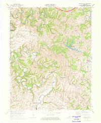 1972 Brush Grove1974 Print · USGSThe rolling hills of Washington County are shown here in the early seventies, centered on the historic Lincoln Homestead State Park. Genealogists can trace family roots through locations like Willisburg, Hardesty, and several rural churches including Mt Zion Ch.
 - 1972 Map of Chaplin, 1974 Print
 1972 Chaplin1974 Print · USGSCentral Kentucky's river valleys and rural uplands are captured here in the early seventies, spanning four county lines. Researchers can trace family roots through numerous small cemeteries and country churches like Highview Ch, Green Chapel, and Price Cem.2 unique versions available
End of results
Showing maps 1-5 of 5
Top cities of Washington County
Frequently asked questions
- What are the different types of historical maps available for Washington County?
- What is the oldest map of Washington County?
- Where can I purchase historical maps of Washington County for my home or office?
- Where can I download high-res historical maps of Washington County?
- Are there historical topographic maps available for Washington County?
- Is there historical aerial imagery available for Washington County?
- Where are historical maps of Washington County sourced from?