1900s (20th Century) Maps of Williamsburg, Kentucky
Explore 7 historic maps of Williamsburg from the 1900s (20th Century). These maps offer a rare glimpse into what life looked like during the 1900s — showing old roads, neighborhoods, homes, and landmarks that have changed or disappeared over time.
Whether you're researching your family's past, planning a metal detecting trip, or studying how Williamsburg's landscape evolved across the 1900s, these high-resolution maps are a powerful tool for exploring the history of this region.
- Focus on a specific era: All maps on this page are from the 1900s, giving you a focused view of this time period.
- See what’s changed: Compare century-old streets, trails, and buildings to today's modern landscape using overlays and satellite layers.
- Research with precision: Use these maps for genealogy, historical research, land use analysis, or educational projects.
- View, download, or print: Maps are fully viewable online in high resolution, and can be downloaded or printed for your own records.
Start exploring Williamsburg's history through authentic maps from the 1900s. This is your window into the past.
Williamsburg, KY maps
(7)- 1952 Map of Wofford, 1953 Print
 1952 Wofford1953 Print · USGSWhitley County in the early fifties shows a landscape of deep river bends and rural communities along the Louisville and Nashville rail line. Genealogists can trace family footprints through numerous small landmarks like White Oak Ch, Canada Sch, and Shiner Sch.
 - 1952 Map of Williamsburg, 1954 Print
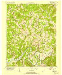
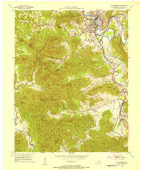 1952 Williamsburg1954 Print · USGSWhitley County's river-and-rail landscape is captured here in the early fifties, centered on the Williamsburg bend. Trace the legacy of rural coal and community through numerous strip mines, the Shelly Knob Lookout Tower, and local landmarks like Cumberland College.
 - 1956 Map of Corbin, 1966 Print
 1956 Corbin1966 Print · USGSThe Kentucky and Tennessee borderlands are captured here in the mid-fifties, showing the region's shift toward modern interstate travel and reservoir development. Genealogists and historians can trace old community lines near Albany and Monticello or locate early rail junctions along the Southern and Tennessee Central lines.3 unique versions available
 - 1958 Map of Corbin
 1958 Corbin1958 Print · USGSThe Upper Cumberland borderlands appear in the late 1950s as massive reservoirs and early atomic-era growth reshape the region. Trace family roots and vanished landmarks near Lake Cumberland, Oak Ridge, and the Cumberland National Forest.
 - 1969 Map of Williamsburg, 1972 Print
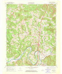
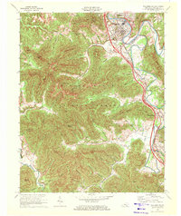 1969 Williamsburg1972 Print · USGSWhitley County at the end of the sixties reveals a transition from traditional coal-and-rail towns to modern highway development. Genealogists can locate family names at Highland Cemetery and trace historical communities like Emlyn and Savoy along the Louisville and Nashville line.2 unique versions available
 - 1969 Map of Wofford, 1972 Print
 1969 Wofford1972 Print · USGSWhitley County's river-bottom lands and coal-country hills are shown here in the late sixties as modern infrastructure arrived. Genealogists can locate family burial sites at Ryan Cem and Steely Cem or trace the early days of the Gatliff State Fish Hatchery.3 unique versions available
 - 1981 Map of Corbin, 1984 Print
 1981 Corbin1984 Print · USGSThe Kentucky and Tennessee borderlands in the early eighties were characterized by coal towns and deep mountain ridges. Trace family history or rail routes through Stearns, Williamsburg, and the mining settlements near Jellico Mountain along the L & N RR.
End of results
Showing maps 1-7 of 7
Top cities near Williamsburg
Top neighborhoods of Williamsburg
Frequently asked questions
- What are the different types of historical maps available for Williamsburg?
- What is the oldest map of Williamsburg?
- Where can I purchase historical maps of Williamsburg for my home or office?
- Where can I download high-res historical maps of Williamsburg?
- Are there historical topographic maps available for Williamsburg?
- Is there historical aerial imagery available for Williamsburg?
- Where are historical maps of Williamsburg sourced from?