
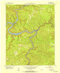
1952 Map of Wofford
USGS Topo · Published 1953About this map
Cumberland National Forest borders the western edge of this territory, where the Cumberland River carves deep, dramatic oxbows at Prewitt Bend and Croley Bend. The landscape is a complex of sharp ridges and hollows, home to numerous rural institutions like White Oak Mission Sch and Log Cabin Ch. The industrial and agricultural character of the early 1950s is evident in the Strip Mines appearing near Faber and the presence of the Gatliff State Fish Hatchery near the rail line. Transportation is anchored by the Louisville and Nashville railroad, which follows the river valley through Wofford toward Williamsburg. This survey captures a specific social geography, documenting a high density of small community centers such as Shiner Sch and Tidal Wave Ch before many were consolidated.
Find a feature on this map
63 named features on this map. Tap any name to fly to it.
Don’t see what you’re looking for? This feature index may not catch every label — zoom into the map to look around manually.
Map Details
Editions of this 1952 Wofford Map
This is the sole edition of this map. No revisions or reprints were ever made.
Other maps of this area

1890 · Williamsburg
USGS Topo · 1:125,000

1894 · Williamsburg
USGS Topo · 1:125,000

1952 · Corbin
USGS Topo · 1:24,000

1952 · Vox
USGS Topo · 1:24,000

1952 · Saxton
USGS Topo · 1:24,000

1952 · Hollyhill
USGS Topo · 1:24,000

1952 · Rockholds
USGS Topo · 1:24,000

1952 · Cumberland Falls
USGS Topo · 1:24,000

1952 · Williamsburg
USGS Topo · 1:24,000
1952 · Sawyer
USGS Topo · 1:24,000