1960s Maps of Woodford County, Kentucky
Explore 6 historic maps of Woodford County from the 1960s. These maps offer a rare glimpse into what life looked like during the 1960s — showing old roads, neighborhoods, homes, and landmarks that have changed or disappeared over time.
Whether you're researching your family's past, planning a metal detecting trip, or studying how Woodford County's landscape evolved across the 1960s, these high-resolution maps are a powerful tool for exploring the history of this region.
- Focus on a specific era: All maps on this page are from the 1960s, giving you a focused view of this time period.
- See what’s changed: Compare century-old streets, trails, and buildings to today's modern landscape using overlays and satellite layers.
- Research with precision: Use these maps for genealogy, historical research, land use analysis, or educational projects.
- View, download, or print: Maps are fully viewable online in high resolution, and can be downloaded or printed for your own records.
Start exploring Woodford County's history through authentic maps from the 1960s. This is your window into the past.
Woodford County, KY maps
(6)- 1960 Map of Winchester
 1960 Winchester1960 Print · USGSCentral Kentucky's diverse landscape is shown here at mid-century, from the bluegrass plains to the rugged Pottsville Escarpment. Genealogists and historians can trace the rail-and-river network connecting towns like Bardstown and Stanford alongside landmarks like Lake Cumberland.
 - 1964 Map of Louisville
 1964 Louisville1964 Print · USGSThe Ohio River valley and Kentucky Bluegrass are captured in the mid-1960s, showing a region balanced between industrial growth and its agrarian roots. Genealogists and historians can trace the development of county seats like Shelbyville and Paris, or locate established institutions such as Georgetown College and Bernheim Forest.
 - 1965 Map of Versailles, 1966 Print
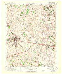 1965 Versailles1966 Print · USGSWoodford County at the mid-century mark shows a landscape of established rail towns and developing parkways. Genealogists and local historians can trace the footprint of family-named landmarks like Steele Cem and early settlements such as Hunter Town and Little Texas.3 unique versions available
 - 1967 Map of Salvisa, 1969 Print
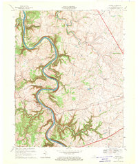
 1967 Salvisa1969 Print · USGSThe Kentucky River meanders through the heart of bluegrass country in the late sixties, defining the borders of Mercer and Woodford counties. Genealogists can trace family names at Wilhoyt Cem and Morris Cem, or locate rural landmarks like Hillsborough Ch and the old Nonesuch Sch.2 unique versions available
 - 1967 Map of Tyrone, 1969 Print
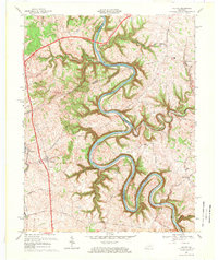
 1967 Tyrone1969 Print · USGSThe Kentucky River valley in the late sixties reveals a landscape of industrial river bends and growing Bluegrass towns. Genealogists and historians can trace family-named routes like McConnells Ferry Road and locate rural landmarks such as Pintsville Ch and Lock No 5.2 unique versions available
 - 1967 Map of Harrodsburg, 1970 Print
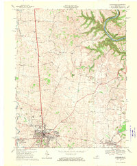 1967 Harrodsburg1970 Print · USGSMercer County is captured here in the late sixties, centered on the growing town of Harrodsburg and the Kentucky River. Researchers can trace family homesteads near New Providence Ch, Burgin, and the river landing at Mundys Landing.3 unique versions available
End of results
Showing maps 1-6 of 6
Top cities of Woodford County
Frequently asked questions
- What are the different types of historical maps available for Woodford County?
- What is the oldest map of Woodford County?
- Where can I purchase historical maps of Woodford County for my home or office?
- Where can I download high-res historical maps of Woodford County?
- Are there historical topographic maps available for Woodford County?
- Is there historical aerial imagery available for Woodford County?
- Where are historical maps of Woodford County sourced from?