1930s Maps of Belle Helene, Louisiana
Explore 2 historic maps of Belle Helene from the 1930s. These maps offer a rare glimpse into what life looked like during the 1930s — showing old roads, neighborhoods, homes, and landmarks that have changed or disappeared over time.
Whether you're researching your family's past, planning a metal detecting trip, or studying how Belle Helene's landscape evolved across the 1930s, these high-resolution maps are a powerful tool for exploring the history of this region.
- Focus on a specific era: All maps on this page are from the 1930s, giving you a focused view of this time period.
- See what’s changed: Compare century-old streets, trails, and buildings to today's modern landscape using overlays and satellite layers.
- Research with precision: Use these maps for genealogy, historical research, land use analysis, or educational projects.
- View, download, or print: Maps are fully viewable online in high resolution, and can be downloaded or printed for your own records.
Start exploring Belle Helene's history through authentic maps from the 1930s. This is your window into the past.
Belle Helene, LA maps
(2)- 1935 Map of Gonzales
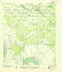 1935 Gonzales1935 Print · USGSThe river parishes of Louisiana come alive in the mid-1930s, showing the vital connection between the winding Mississippi River and the growing interior. Genealogists can locate family landmarks like Conway Plantation or the industrial Belle Helene Refinery and St Paul Church.
 - 1939 Map of Donaldsonville, 1953 Print
 1939 Donaldsonville1953 Print · USGSLouisiana's river parishes are captured here in the late 1930s, showing a landscape defined by the winding Mississippi River and its rich agricultural traditions. Genealogists and historians can trace family roots through numerous combined school and church sites like Little Zion Sch Ch & Cem or the sprawling riverside Monroe Plantation.5 unique versions available
End of results
Showing maps 1-2 of 2
Top cities near Belle Helene
- Baton Rouge historical maps
- Saint George historical maps
- St. George historical maps
- Prairieville historical maps
- Gonzales historical maps
- Donaldsonville historical maps
See more
Frequently asked questions
- What are the different types of historical maps available for Belle Helene?
- What is the oldest map of Belle Helene?
- Where can I purchase historical maps of Belle Helene for my home or office?
- Where can I download high-res historical maps of Belle Helene?
- Are there historical topographic maps available for Belle Helene?
- Is there historical aerial imagery available for Belle Helene?
- Where are historical maps of Belle Helene sourced from?