1920s Maps of Madewood, Louisiana
Explore 1 historic maps of Madewood from the 1920s. These maps offer a rare glimpse into what life looked like during the 1920s — showing old roads, neighborhoods, homes, and landmarks that have changed or disappeared over time.
Whether you're researching your family's past, planning a metal detecting trip, or studying how Madewood's landscape evolved across the 1920s, these high-resolution maps are a powerful tool for exploring the history of this region.
- Focus on a specific era: All maps on this page are from the 1920s, giving you a focused view of this time period.
- See what’s changed: Compare century-old streets, trails, and buildings to today's modern landscape using overlays and satellite layers.
- Research with precision: Use these maps for genealogy, historical research, land use analysis, or educational projects.
- View, download, or print: Maps are fully viewable online in high resolution, and can be downloaded or printed for your own records.
Start exploring Madewood's history through authentic maps from the 1920s. This is your window into the past.
Madewood, LA maps
(1)- 1927 Map of Thibodaux NW
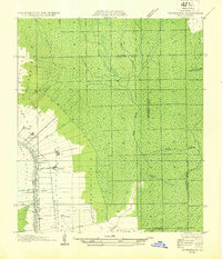 1927 Thibodaux NW1927 Print · USGSAssumption Parish at the end of the 1920s reveals the intricate ribbon-strip land patterns along the bayous. Genealogists and historians can trace family-named settlements like Albemarle, Aurelia, and Bertie, or locate the St Thomas Sch and Woodlawn Ch.
End of results
Showing maps 1-1 of 1
Top cities near Madewood
- Thibodaux historical maps
- Morgan City historical maps
- Donaldsonville historical maps
- Berwick historical maps
- White Castle historical maps
- Sorrento historical maps
See more
Frequently asked questions
- What are the different types of historical maps available for Madewood?
- What is the oldest map of Madewood?
- Where can I purchase historical maps of Madewood for my home or office?
- Where can I download high-res historical maps of Madewood?
- Are there historical topographic maps available for Madewood?
- Is there historical aerial imagery available for Madewood?
- Where are historical maps of Madewood sourced from?