1900s (20th Century) Maps of Ikes, Louisiana
Explore 8 historic maps of Ikes from the 1900s (20th Century). These maps offer a rare glimpse into what life looked like during the 1900s — showing old roads, neighborhoods, homes, and landmarks that have changed or disappeared over time.
Whether you're researching your family's past, planning a metal detecting trip, or studying how Ikes's landscape evolved across the 1900s, these high-resolution maps are a powerful tool for exploring the history of this region.
- Focus on a specific era: All maps on this page are from the 1900s, giving you a focused view of this time period.
- See what’s changed: Compare century-old streets, trails, and buildings to today's modern landscape using overlays and satellite layers.
- Research with precision: Use these maps for genealogy, historical research, land use analysis, or educational projects.
- View, download, or print: Maps are fully viewable online in high resolution, and can be downloaded or printed for your own records.
Start exploring Ikes's history through authentic maps from the 1900s. This is your window into the past.
Ikes, LA maps
(8)- 1947 Map of Ikes
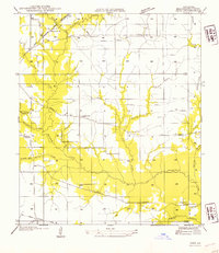
 1947 Ikes1947 Print · USGSBeauregard Parish in the mid-1930s and 1940s reveals a landscape defined by logging history and rural settlement patterns. Researchers can trace family sites near Whittaker Cem, Ikes, and the rail lines of the Gulf Colorado and Santa Fe.
 - 1952 Map of Lake Charles
 1952 Lake Charles1952 Print · USGSSouthwest Louisiana is captured here in the mid-fifties, showing a landscape defined by the rise of the petrochemical industry and deep-water navigation. Researchers can trace family roots through numerous small-town settlements and oil developments like Nibletts Bluff, the Lockport Oil Field, and Starks.
 - 1954 Map of Ikes
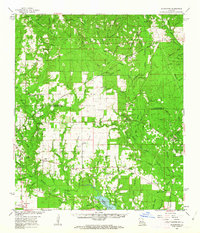
 1954 Ikes1954 Print · USGSBeauregard Parish in the mid-1950s reflects a landscape shaped by logging history and rural community life. Researchers can trace the Old Logging Railroad Grade and locate ancestral sites like Whittaker Cem or the settlement at Ikes.
 - 1954 Map of Lake Charles, 1964 Print
 1954 Lake Charles1964 Print · USGSSouthwest Louisiana in the mid-fifties is defined by its massive petroleum industry and its complex network of bayous and rail lines. Researchers can trace the development of the Sulphur Mines Oil Field or locate historic settlements like Longville and De Quincy.3 unique versions available
 - 1961 Map of Sugartown, 1963 Print
 1961 Sugartown1963 Print · USGSCentral Louisiana in the early sixties was a landscape of timber stands and winding creek bottoms along the Vernon and Beauregard Parish border. Genealogists and historians can trace rural life through landmarks like Lone Star Sch, Wisby Memorial Ch Cem, and the Sugartown Lookout Tower.2 unique versions available
 - 1986 Map of DeRidder
 1986 DeRidder1986 Print · USGSThe Louisiana-Texas borderlands come to life in the mid-eighties, showcasing the timber country and rail corridors of the Sabine River valley. Researchers can trace the legacy of small communities and transit lines through Merryville, Holly Springs, and the Missouri Pacific railroad.2 unique versions available
 - 1986 Map of Boneset Creek
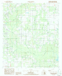 1986 Boneset Creek1986 Print · USGSBeauregard Parish in the mid-1980s shows a landscape transitioning from rail-dependent industry to modern utility. You can trace the Old Railroad Grade past Longacre or locate family landmarks near Bundick Lake and Hickory Hollow.
 - 1994 Map of Boneset Creek, 1997 Print
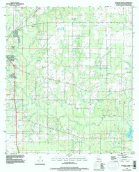 1994 Boneset Creek1997 Print · USGSNorth of Bundick Lake in the 1990s, this Beauregard Parish landscape was defined by its intricate network of creek branches and rural industry. Researchers can trace family sites at several Cem locations and explore the area around Longacre and Bundick Creek.
End of results
Showing maps 1-8 of 8
Top cities near Ikes
Frequently asked questions
- What are the different types of historical maps available for Ikes?
- What is the oldest map of Ikes?
- Where can I purchase historical maps of Ikes for my home or office?
- Where can I download high-res historical maps of Ikes?
- Are there historical topographic maps available for Ikes?
- Is there historical aerial imagery available for Ikes?
- Where are historical maps of Ikes sourced from?