1900s (20th Century) Maps of Juanita, Louisiana
Explore 7 historic maps of Juanita from the 1900s (20th Century). These maps offer a rare glimpse into what life looked like during the 1900s — showing old roads, neighborhoods, homes, and landmarks that have changed or disappeared over time.
Whether you're researching your family's past, planning a metal detecting trip, or studying how Juanita's landscape evolved across the 1900s, these high-resolution maps are a powerful tool for exploring the history of this region.
- Focus on a specific era: All maps on this page are from the 1900s, giving you a focused view of this time period.
- See what’s changed: Compare century-old streets, trails, and buildings to today's modern landscape using overlays and satellite layers.
- Research with precision: Use these maps for genealogy, historical research, land use analysis, or educational projects.
- View, download, or print: Maps are fully viewable online in high resolution, and can be downloaded or printed for your own records.
Start exploring Juanita's history through authentic maps from the 1900s. This is your window into the past.
Juanita, LA maps
(7)- 1947 Map of Oretta
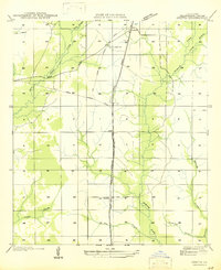 1947 Oretta1947 Print · USGSBeauregard Parish timber and rail operations are preserved here during the mid-forties, showing the vital connection between industry and small settlements. Trace the footprints of Oretta, Juanita, and the Old Logging Railroad Grade through the piney woods.
 - 1952 Map of Lake Charles
 1952 Lake Charles1952 Print · USGSSouthwest Louisiana is captured here in the mid-fifties, showing a landscape defined by the rise of the petrochemical industry and deep-water navigation. Researchers can trace family roots through numerous small-town settlements and oil developments like Nibletts Bluff, the Lockport Oil Field, and Starks.
 - 1954 Map of Lake Charles, 1964 Print
 1954 Lake Charles1964 Print · USGSSouthwest Louisiana in the mid-fifties is defined by its massive petroleum industry and its complex network of bayous and rail lines. Researchers can trace the development of the Sulphur Mines Oil Field or locate historic settlements like Longville and De Quincy.3 unique versions available
 - 1956 Map of Oretta
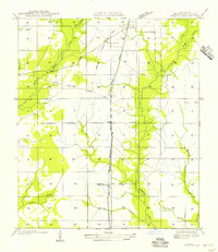 1956 Oretta1956 Print · USGSMid-century Beauregard Parish reveals a landscape shaped by timber and transit during this era of transition. Genealogists and historians can trace the development of Oretta, Seale, and Juanita along the Kansas City Southern Railroad.
 - 1961 Map of Singer, 1963 Print
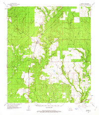 1961 Singer1963 Print · USGSBeauregard Parish in the early sixties is a landscape of timbered branches and emerging oil fields along the Southern Kansas City railroad. Genealogists and local historians can locate rural landmarks like Holly Grove Ch, Juanita, and the Oretta Cem.2 unique versions available
 - 1986 Map of DeRidder
 1986 DeRidder1986 Print · USGSThe Louisiana-Texas borderlands come to life in the mid-eighties, showcasing the timber country and rail corridors of the Sabine River valley. Researchers can trace the legacy of small communities and transit lines through Merryville, Holly Springs, and the Missouri Pacific railroad.2 unique versions available
 - 1986 Map of Oretta, 1987 Print
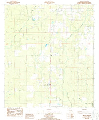 1986 Oretta1987 Print · USGSSouthern Beauregard Parish comes into focus during the mid-eighties as a landscape of timber management and small rural communities. Researchers can trace the layout of Oretta and Juanita, or locate the FISH HATCHERY and Cem near the winding Bear Head Creek.
End of results
Showing maps 1-7 of 7
Top cities near Juanita
Frequently asked questions
- What are the different types of historical maps available for Juanita?
- What is the oldest map of Juanita?
- Where can I purchase historical maps of Juanita for my home or office?
- Where can I download high-res historical maps of Juanita?
- Are there historical topographic maps available for Juanita?
- Is there historical aerial imagery available for Juanita?
- Where are historical maps of Juanita sourced from?