Old Maps of River Bend, Bossier City
Explore 16 old maps of River Bend, spanning from 1941 to today. These high-resolution historic maps reveal how streets, neighborhoods, landmarks, and natural features evolved over time — perfect for genealogy, metal detecting, research, and local history exploration.
What you can do with these maps:
- See how River Bend changed over time: Compare historical maps to modern-day views to trace roads, homesites, rail lines & more.
- View detailed metadata: Each map includes creators, publishers, year, scale, and archive source.
- Overlay maps with satellite & LiDAR: Visualize the past alongside modern tools to explore terrain & human change.
- Trusted historical sources: Maps sourced from the USGS, Library of Congress, and other archives.
- Access maps your way: View online, download high-res files, or order prints for personal or research use.
Start exploring old maps of River Bend to uncover forgotten places, hidden landmarks, and the deep history beneath your feet.
River Bend, Bossier City maps
(16)- 1941 Map of Forbing
 1941 Forbing1941 Print · USGSThe outskirts of Shreveport and the shifting bends of the Red River come to life just before the mid-century expansion. Genealogists and historians can locate specific rural institutions such as Centenary College, Hood Cem, and the Good Hope Sch among the river's many points and bayous.
 - 1948 Map of Caspiana
 1948 Caspiana1948 Print · USGSNorthwest Louisiana south of Shreveport is captured here in the late 1940s as the river-and-rail economy shaped the Red River Valley. Genealogists can trace family footprints across dozens of rural landmarks like Blenheim Sch, Robinson Chapel, and Evergreen Cem.
 - 1955 Map of Shreveport
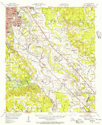
 1955 Shreveport1955 Print · USGSNorthern Louisiana in the mid-fifties is captured here as a landscape of military bases, vast oil fields, and burgeoning college towns. Genealogists and historians can trace the rail-and-river economy through the Monroe Gas Field, Grambling College, and Barksdale Air Force Base.3 unique versions available
 - 1955 Map of Shreveport East, 1956 Print
 1955 Shreveport East1956 Print · USGSThe riverfronts of Shreveport and Bossier City are shown in the mid-fifties as urban growth began to fill the bends of the Red River. Researchers can trace the development of Barksdale Air Force Base and locate local landmarks like Byrd High Sch and Red River Cem.
 - 1955 Map of Caspiana, 1956 Print
 1955 Caspiana1956 Print · USGSShreveport and the Red River valley are captured here in the mid-fifties, just as the region's military and agricultural footprint was expanding. Researchers can trace the boundaries of Barksdale Air Force Base or locate rural landmarks like Daisy Grove Sch and Oakland Cem.3 unique versions available
 - 1956 Map of Shreveport
 1956 Shreveport1956 Print · USGSNorthern Louisiana during the mid-fifties presents a complex landscape of booming oil fields and strategic military installations. Genealogists and historians can trace the infrastructure of the Monroe Gas Field and family-named locales from Cotton Valley to Jonesboro.
 - 1959 Map of Shreveport East, 1960 Print
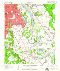 1959 Shreveport East1960 Print · USGSShreveport and Bossier City are seen at a mid-century peak of expansion along the oxbows of the Red River. Researchers can trace neighborhood growth near Centenary College or locate rural landmarks like Red River Cem and the Mary Goula Ch.2 unique versions available
 - 1975 Map of Shreveport East, 1976 Print
 1975 Shreveport East1976 Print · USGSShreveport and Bossier City appear during the mid-seventies, split by the winding course of the Red River. Researchers can trace the layout of Barksdale Air Force Base and the dense urban development within Shreveport.
 - 1980 Map of Shreveport East
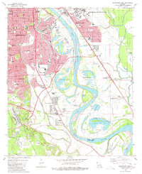 1980 Shreveport East1980 Print · USGSThe riverfront and expanding suburbs of Shreveport and Bossier City are captured here during the late 1970s. Researchers can trace local landmarks like Centenary College, Red River Cem, and the development of Anderson Island.3 unique versions available
 - 1984 Map of Shreveport
 1984 Shreveport1984 Print · USGSNorthern Louisiana at the peak of the 1980s reveals a landscape of massive water management projects and Cold War military hubs. Trace the rail lines of the Kansas City Southern Ry past Barksdale Air Force Base and the high ground of Driskill Mountain.2 unique versions available
 - 1985 Map of Shreveport South
 1985 Shreveport South1985 Print · USGSNorthwest Louisiana in the mid-eighties shows a landscape defined by the Red River and a transition from urban centers to deep timberland. Researchers can trace the rail-and-river economy through landmarks like Barksdale Air Force Base, the Sligo Oil and Gas Field, and Lake Bistineau.2 unique versions available
 - 2012 Map of Shreveport East, 2012 Print
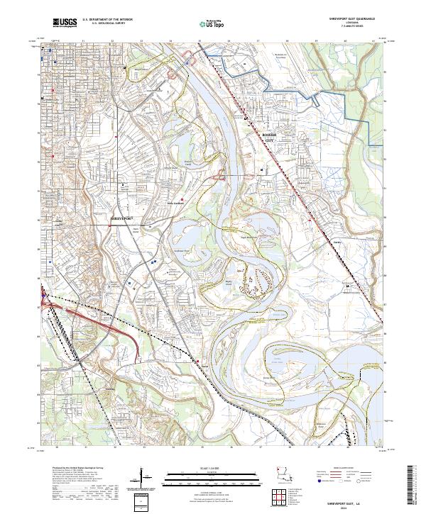
 2012 Shreveport East2012 Print · USGSCovers River Bend, including Shreveport, Bossier City, and other nearby areas
 - 2015 Map of Shreveport East, 2015 Print
 2015 Shreveport East2015 Print · USGSCovers River Bend, including Shreveport, Bossier City, and other nearby areas
 - 2018 Map of Shreveport East, 2018 Print
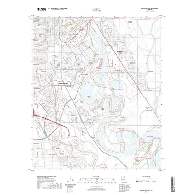
 2018 Shreveport East2018 Print · USGSCovers River Bend, including Shreveport, Bossier City, and other nearby areas
 - 2020 Map of Shreveport East, 2020 Print
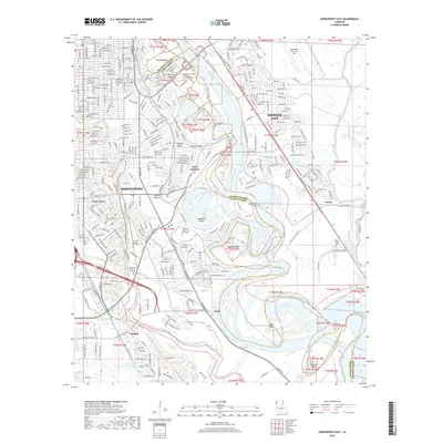
 2020 Shreveport East2020 Print · USGSCovers River Bend, including Shreveport, Bossier City, and other nearby areas
 - 2024 Map of Shreveport East, 2024 Print
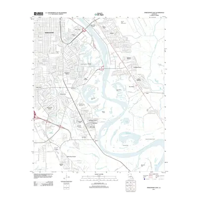
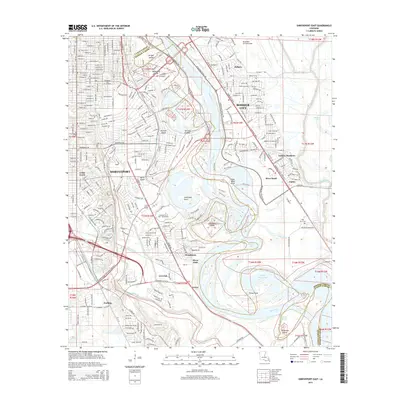
 2024 Shreveport East2024 Print · USGSShreveport and Bossier City are captured here along the shifting banks of the Red River in 2024. Genealogists and historians can trace suburban growth and river landmarks like Red River Cem, Anderson Island, and the historic Centenary College of Louisiana.
End of results
Showing maps 1-16 of 16
Top cities near River Bend
- Shreveport historical maps
- Bossier City historical maps
- Haughton historical maps
- Blanchard historical maps
- Benton historical maps
- Stonewall historical maps
See more
Frequently asked questions
- What are the different types of historical maps available for River Bend?
- What is the oldest map of River Bend?
- Where can I purchase historical maps of River Bend for my home or office?
- Where can I download high-res historical maps of River Bend?
- Are there historical topographic maps available for River Bend?
- Is there historical aerial imagery available for River Bend?
- Where are historical maps of River Bend sourced from?