1900s (20th Century) Maps of Redland, Louisiana
Explore 8 historic maps of Redland from the 1900s (20th Century). These maps offer a rare glimpse into what life looked like during the 1900s — showing old roads, neighborhoods, homes, and landmarks that have changed or disappeared over time.
Whether you're researching your family's past, planning a metal detecting trip, or studying how Redland's landscape evolved across the 1900s, these high-resolution maps are a powerful tool for exploring the history of this region.
- Focus on a specific era: All maps on this page are from the 1900s, giving you a focused view of this time period.
- See what’s changed: Compare century-old streets, trails, and buildings to today's modern landscape using overlays and satellite layers.
- Research with precision: Use these maps for genealogy, historical research, land use analysis, or educational projects.
- View, download, or print: Maps are fully viewable online in high resolution, and can be downloaded or printed for your own records.
Start exploring Redland's history through authentic maps from the 1900s. This is your window into the past.
Redland, LA maps
(8)- 1950 Map of Plain Dealing NE
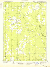 1950 Plain Dealing NE1950 Print · USGSUpper Bossier Parish was a landscape of timber and oil during the mid-century, defined by small settlements and resource extraction. Genealogists and researchers can trace local landmarks like Elizabeth Sch, the Goodwin Sawmill, and the Carterville Oil Field.
 - 1953 Map of Carterville, 1954 Print
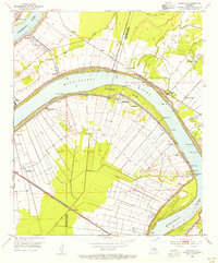 1953 Carterville1954 Print · USGSThe riverfront between Iberville and Ascension Parishes was a dense network of landings and railroads in the early 1950s. Researchers can trace the layout of the National Leprosarium at Carville or locate family sites near St Phillips Ch and Hohen Solms.
 - 1955 Map of Shreveport
 1955 Shreveport1955 Print · USGSNorthern Louisiana in the mid-fifties is captured here as a landscape of military bases, vast oil fields, and burgeoning college towns. Genealogists and historians can trace the rail-and-river economy through the Monroe Gas Field, Grambling College, and Barksdale Air Force Base.3 unique versions available
 - 1955 Map of Plain Dealing, 1956 Print
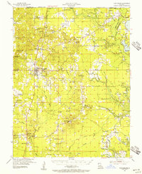 1955 Plain Dealing1956 Print · USGSNorthern Bossier Parish during the mid-fifties shows a landscape defined by burgeoning oil fields and quiet rural communities. Genealogists and local historians can locate numerous family-named landmarks and country institutions like Louisville Sch, Collinsburg Cem, and the St Marys Ch.4 unique versions available
 - 1956 Map of Shreveport
 1956 Shreveport1956 Print · USGSNorthern Louisiana during the mid-fifties presents a complex landscape of booming oil fields and strategic military installations. Genealogists and historians can trace the infrastructure of the Monroe Gas Field and family-named locales from Cotton Valley to Jonesboro.
 - 1981 Map of Carterville
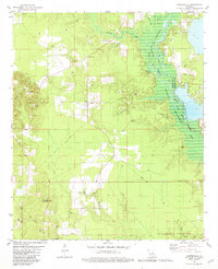 1981 Carterville1981 Print · USGSNorthwestern Louisiana oil and gas country meets the conservation lands of the Bodcau valley as they appeared in the late seventies. Researchers can trace rural lineages through family-named sites like Walker Chapel and Rogers Cem or locate the Plain Dealing Lookout Tower.
 - 1984 Map of Shreveport
 1984 Shreveport1984 Print · USGSNorthern Louisiana at the peak of the 1980s reveals a landscape of massive water management projects and Cold War military hubs. Trace the rail lines of the Kansas City Southern Ry past Barksdale Air Force Base and the high ground of Driskill Mountain.2 unique versions available
 - 1986 Map of Shreveport North
 1986 Shreveport North1986 Print · USGSNorthern Louisiana in the mid-eighties shows a landscape of expansive river bottoms and growing suburban centers. Genealogists and historians can trace the development of Shreveport, the infrastructure of Barksdale Air Force Base, and rural life in Rocky Mount.2 unique versions available
End of results
Showing maps 1-8 of 8
Top cities near Redland
- Springhill historical maps
- Cullen historical maps
- Cotton Valley historical maps
- Plain Dealing historical maps
- Sarepta historical maps
- Taylor historical maps
See more
Frequently asked questions
- What are the different types of historical maps available for Redland?
- What is the oldest map of Redland?
- Where can I purchase historical maps of Redland for my home or office?
- Where can I download high-res historical maps of Redland?
- Are there historical topographic maps available for Redland?
- Is there historical aerial imagery available for Redland?
- Where are historical maps of Redland sourced from?