1970s Maps of Shoreline, Louisiana
Explore 2 historic maps of Shoreline from the 1970s. These maps offer a rare glimpse into what life looked like during the 1970s — showing old roads, neighborhoods, homes, and landmarks that have changed or disappeared over time.
Whether you're researching your family's past, planning a metal detecting trip, or studying how Shoreline's landscape evolved across the 1970s, these high-resolution maps are a powerful tool for exploring the history of this region.
- Focus on a specific era: All maps on this page are from the 1970s, giving you a focused view of this time period.
- See what’s changed: Compare century-old streets, trails, and buildings to today's modern landscape using overlays and satellite layers.
- Research with precision: Use these maps for genealogy, historical research, land use analysis, or educational projects.
- View, download, or print: Maps are fully viewable online in high resolution, and can be downloaded or printed for your own records.
Start exploring Shoreline's history through authentic maps from the 1970s. This is your window into the past.
Shoreline, LA maps
(2)- 1971 Map of Vivian South, 1973 Print
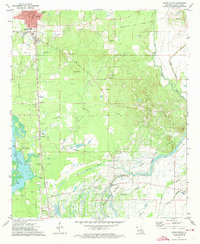 1971 Vivian South1973 Print · USGSCaddo Parish in the early 1970s reveals a landscape defined by an extensive petroleum industry and a rich network of rural communities. Genealogists and historians can trace family roots through numerous sites like New Hope Cem, Mt Superior Ch, and the settlement at Oil City.2 unique versions available
 - 1971 Map of Vivian, 1974 Print
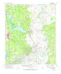 1971 Vivian1974 Print · USGSCaddo Parish at the start of the 1970s shows a landscape transformed by the energy industry and an intricate network of bayous. Researchers can trace family sites at Centerville Cem and Antioch Ch or explore the rail hubs of Vivian and Oil City.2 unique versions available
End of results
Showing maps 1-2 of 2
Top cities near Shoreline
- Shreveport historical maps
- Vivian historical maps
- Blanchard historical maps
- Benton historical maps
- Oil City historical maps
- Mooringsport historical maps
See more
Frequently asked questions
- What are the different types of historical maps available for Shoreline?
- What is the oldest map of Shoreline?
- Where can I purchase historical maps of Shoreline for my home or office?
- Where can I download high-res historical maps of Shoreline?
- Are there historical topographic maps available for Shoreline?
- Is there historical aerial imagery available for Shoreline?
- Where are historical maps of Shoreline sourced from?