1990s Maps of Sulphur, Louisiana
Explore 6 historic maps of Sulphur from the 1990s. These maps offer a rare glimpse into what life looked like during the 1990s — showing old roads, neighborhoods, homes, and landmarks that have changed or disappeared over time.
Whether you're researching your family's past, planning a metal detecting trip, or studying how Sulphur's landscape evolved across the 1990s, these high-resolution maps are a powerful tool for exploring the history of this region.
- Focus on a specific era: All maps on this page are from the 1990s, giving you a focused view of this time period.
- See what’s changed: Compare century-old streets, trails, and buildings to today's modern landscape using overlays and satellite layers.
- Research with precision: Use these maps for genealogy, historical research, land use analysis, or educational projects.
- View, download, or print: Maps are fully viewable online in high resolution, and can be downloaded or printed for your own records.
Start exploring Sulphur's history through authentic maps from the 1990s. This is your window into the past.
Sulphur, LA maps
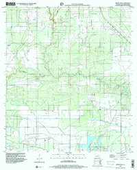
(6)- 1994 Map of Sulphur, 1996 Print
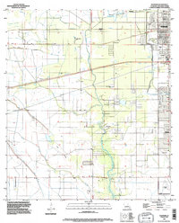 1994 Sulphur1996 Print · USGSCalcasieu Parish comes into focus during the mid-nineties as the industrial and residential centers of Sulphur and Carlyss expand. Researchers can trace local landmarks like Roseland Cem, the historic site of Brimstone, and the regional Southland Field.
 - 1994 Map of Westlake, 1996 Print
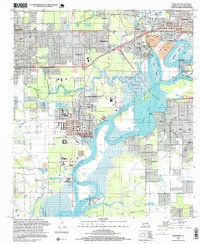
 1994 Westlake1996 Print · USGSThe industrial and maritime heart of Calcasieu Parish is revealed here during the mid-nineties, showing the intersection of heavy industry and residential growth. Genealogists and historians can locate family plots at Farquerar Cem and Burleson Cem or trace the early waterfront at Vincent Landing.
 - 1996 Map of Westlake, 1999 Print
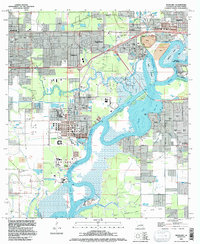
 1996 Westlake1999 Print · USGSThe Calcasieu River waterfront was a hub of petrochemical industry and maritime commerce in the mid-nineties. Genealogists and historians can trace family locations through Farquarer Cem or the settlements of Mossville and Vincent Landing.
 - 1998 Map of Sulphur, 2000 Print
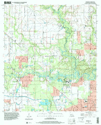
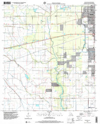 1998 Sulphur2000 Print · USGSCalcasieu Parish at the close of the twentieth century shows a landscape defined by industry and water management. Researchers can trace the development of Sulphur and Carlyss, locating landmarks like Roseland Cem and the historic area of Brimstone.
 - 1998 Map of Brimstone, 2000 Print
 1998 Brimstone2000 Print · USGSThe industrial wetlands of Calcasieu Parish are documented here at the end of the millennium, showing a landscape defined by oil extraction. Researchers can trace the extensive pipelines and the operations at Edgerly Oil Field or locate the De Quincy Lookout Tower.
 - 1998 Map of Buhler, 2002 Print
 1998 Buhler2002 Print · USGSCalcasieu Parish comes to life in this late twentieth-century survey, showcasing the river-bound communities north of Lake Charles. Researchers can trace rural landmarks like the Indian Bayou Ferry and the Willow Spring School alongside family sites like Lyle Cem.
End of results
Showing maps 1-6 of 6
Top cities near Sulphur
Top neighborhoods of Sulphur
Frequently asked questions
- What are the different types of historical maps available for Sulphur?
- What is the oldest map of Sulphur?
- Where can I purchase historical maps of Sulphur for my home or office?
- Where can I download high-res historical maps of Sulphur?
- Are there historical topographic maps available for Sulphur?
- Is there historical aerial imagery available for Sulphur?
- Where are historical maps of Sulphur sourced from?