1960s Maps of Turkey Creek, Louisiana
Explore 3 historic maps of Turkey Creek from the 1960s. These maps offer a rare glimpse into what life looked like during the 1960s — showing old roads, neighborhoods, homes, and landmarks that have changed or disappeared over time.
Whether you're researching your family's past, planning a metal detecting trip, or studying how Turkey Creek's landscape evolved across the 1960s, these high-resolution maps are a powerful tool for exploring the history of this region.
- Focus on a specific era: All maps on this page are from the 1960s, giving you a focused view of this time period.
- See what’s changed: Compare century-old streets, trails, and buildings to today's modern landscape using overlays and satellite layers.
- Research with precision: Use these maps for genealogy, historical research, land use analysis, or educational projects.
- View, download, or print: Maps are fully viewable online in high resolution, and can be downloaded or printed for your own records.
Start exploring Turkey Creek's history through authentic maps from the 1960s. This is your window into the past.
Turkey Creek, LA maps
(3)- 1967 Map of Cocodrie Lake, 1968 Print
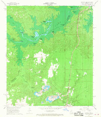 1967 Cocodrie Lake1968 Print · USGSLouisiana's central wetlands and small railroad towns are caught in detail during the late sixties. Genealogists and local historians can trace family locations near Oak Grove Cemetery, the community of Meridian, and the old Sand and Gravel Pits.2 unique versions available
 - 1967 Map of Turkey Creek, 1969 Print
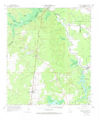 1967 Turkey Creek1969 Print · USGSEvangeline Parish and the surrounding timberlands are shown here in the late sixties, a landscape defined by rail lines and swampy brakes. Genealogists and historians can trace the Chicago Rock Island and Pacific Railroad through Pine Prairie or locate family markers at Belle Chaney Springs Cem and Griffin Cem.
 - 1967 Map of Pine Prairie, 1993 Print
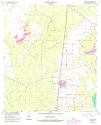 1967 Pine Prairie1993 Print · USGSEvangeline Parish at the end of the 1960s shows a landscape of oil extraction and deep-rooted family history. Genealogists and researchers can trace local heritage through St Peters Cem, the Pine Prairie Oil Field, and the Old Railroad Grade.
End of results
Showing maps 1-3 of 3
Top cities near Turkey Creek
- Oakdale historical maps
- Ville Platte historical maps
- Bunkie historical maps
- Glenmora historical maps
- Lecompte historical maps
- Pine Prairie historical maps
See more
Frequently asked questions
- What are the different types of historical maps available for Turkey Creek?
- What is the oldest map of Turkey Creek?
- Where can I purchase historical maps of Turkey Creek for my home or office?
- Where can I download high-res historical maps of Turkey Creek?
- Are there historical topographic maps available for Turkey Creek?
- Is there historical aerial imagery available for Turkey Creek?
- Where are historical maps of Turkey Creek sourced from?