1940s Maps of Tyrone, Louisiana
Explore 2 historic maps of Tyrone from the 1940s. These maps offer a rare glimpse into what life looked like during the 1940s — showing old roads, neighborhoods, homes, and landmarks that have changed or disappeared over time.
Whether you're researching your family's past, planning a metal detecting trip, or studying how Tyrone's landscape evolved across the 1940s, these high-resolution maps are a powerful tool for exploring the history of this region.
- Focus on a specific era: All maps on this page are from the 1940s, giving you a focused view of this time period.
- See what’s changed: Compare century-old streets, trails, and buildings to today's modern landscape using overlays and satellite layers.
- Research with precision: Use these maps for genealogy, historical research, land use analysis, or educational projects.
- View, download, or print: Maps are fully viewable online in high resolution, and can be downloaded or printed for your own records.
Start exploring Tyrone's history through authentic maps from the 1940s. This is your window into the past.
Tyrone, LA maps
(2)- 1947 Map of Basile
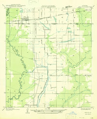 1947 Basile1947 Print · USGSBasile and the surrounding Louisiana prairie are captured here in the late 1940s as the region's agricultural and rail networks were fully established. Researchers can trace family sites near Reed Cem and St Monica Ch, or follow the industrial waterworks of the Mamou Canal.
 - 1949 Map of Basile
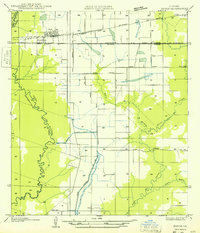 1949 Basile1949 Print · USGSLouisiana's prairie and bayou country meet in the late 1940s at the junction of four different parishes. Researchers can trace the family landmarks of this agricultural landscape, from the Reed Cem and St Monica Ch to the remote Kaplan Pump Sta.
End of results
Showing maps 1-2 of 2
Top cities near Tyrone
- Eunice historical maps
- Ville Platte historical maps
- Mamou historical maps
- Basile historical maps
- Iota historical maps
- Elton historical maps
See more
Frequently asked questions
- What are the different types of historical maps available for Tyrone?
- What is the oldest map of Tyrone?
- Where can I purchase historical maps of Tyrone for my home or office?
- Where can I download high-res historical maps of Tyrone?
- Are there historical topographic maps available for Tyrone?
- Is there historical aerial imagery available for Tyrone?
- Where are historical maps of Tyrone sourced from?