1980s Maps of Baskin, Louisiana
Explore 4 historic maps of Baskin from the 1980s. These maps offer a rare glimpse into what life looked like during the 1980s — showing old roads, neighborhoods, homes, and landmarks that have changed or disappeared over time.
Whether you're researching your family's past, planning a metal detecting trip, or studying how Baskin's landscape evolved across the 1980s, these high-resolution maps are a powerful tool for exploring the history of this region.
- Focus on a specific era: All maps on this page are from the 1980s, giving you a focused view of this time period.
- See what’s changed: Compare century-old streets, trails, and buildings to today's modern landscape using overlays and satellite layers.
- Research with precision: Use these maps for genealogy, historical research, land use analysis, or educational projects.
- View, download, or print: Maps are fully viewable online in high resolution, and can be downloaded or printed for your own records.
Start exploring Baskin's history through authentic maps from the 1980s. This is your window into the past.
Baskin, LA maps
(4)- 1982 Map of Tallulah, 1983 Print
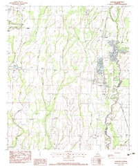
 1982 Tallulah1983 Print · USGSNortheast Louisiana in the early eighties was a landscape of intricate oxbow lakes and railroad towns. Researchers can trace the heritage of parish centers like Tallulah and Winnsboro, or locate rural landmarks near Yucatan Lake and the Illinois Central Gulf tracks.
 - 1982 Map of Mangham, 1983 Print
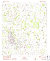
 1982 Mangham1983 Print · USGSThe Richland and Franklin Parish line comes alive in the early eighties as a network of rail and water. Genealogists can trace family roots at Gwin Mem Cem, China Grove Ch, and the settlement of Archibald along the Missouri Pacific.
 - 1983 Map of Winnsboro, 1984 Print
 1983 Winnsboro1984 Print · USGSFranklin Parish during the early eighties shows a landscape defined by the intersection of rail, agriculture, and bayou. Researchers can trace family sites at Old Winnsboro Cem, Wayside Ch, and the Macon Ridge Agr Exper Sta.
 - 1987 Map of Baskinton
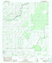 1987 Baskinton1987 Print · USGSRichland and Franklin Parishes in the late 1980s are defined by a network of engineered waterways and rural farmsteads. Researchers can trace the path of Big Creek and locate landmarks such as the Lookout Tower or the settlements of Baskin and Baskinton.
End of results
Showing maps 1-4 of 4
Top cities near Baskin
Frequently asked questions
- What are the different types of historical maps available for Baskin?
- What is the oldest map of Baskin?
- Where can I purchase historical maps of Baskin for my home or office?
- Where can I download high-res historical maps of Baskin?
- Are there historical topographic maps available for Baskin?
- Is there historical aerial imagery available for Baskin?
- Where are historical maps of Baskin sourced from?