1900s (20th Century) Maps of Chase, Louisiana
Explore 8 historic maps of Chase from the 1900s (20th Century). These maps offer a rare glimpse into what life looked like during the 1900s — showing old roads, neighborhoods, homes, and landmarks that have changed or disappeared over time.
Whether you're researching your family's past, planning a metal detecting trip, or studying how Chase's landscape evolved across the 1900s, these high-resolution maps are a powerful tool for exploring the history of this region.
- Focus on a specific era: All maps on this page are from the 1900s, giving you a focused view of this time period.
- See what’s changed: Compare century-old streets, trails, and buildings to today's modern landscape using overlays and satellite layers.
- Research with precision: Use these maps for genealogy, historical research, land use analysis, or educational projects.
- View, download, or print: Maps are fully viewable online in high resolution, and can be downloaded or printed for your own records.
Start exploring Chase's history through authentic maps from the 1900s. This is your window into the past.
Chase, LA maps
(8)- 1935 Map of Winnsboro, 1936 Print
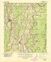 1935 Winnsboro1936 Print · USGSFranklin Parish in the mid-1930s is a landscape of railroad towns and timber landings defined by the winding Macon Bayou. Researchers can trace the Missouri Pacific line through Winnsboro or locate the many historic river crossings like Eureka Ferry and Killens Ferry.2 unique versions available
 - 1955 Map of Jackson
 1955 Jackson1955 Print · USGSThe Lower Mississippi Valley at the middle of the century reveals a landscape of deep river meanders and growing rail hubs. Genealogists and historians can trace the mid-century footprints of Vicksburg National Military Park, old river landings at Port Gibson, and the rail corridors of the Illinois Central Railroad.3 unique versions available
 - 1958 Map of Winnsboro
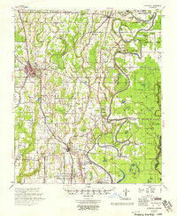 1958 Winnsboro1958 Print · USGSThe fertile landscape of Franklin Parish comes to life in the late 1950s, showing a region defined by the Missouri Pacific Railroad and the winding Macon Bayou. Genealogists and local historians can trace family locations near landmarks like True Light Cem & Ch, the Franklin Parish Training Sch, and Lorelein.
 - 1961 Map of Jackson
 1961 Jackson1961 Print · USGSThe Lower Mississippi Delta and the state capital area are captured here during the post-war era of infrastructure expansion. Researchers can trace the complex river oxbows and rail lines connecting Vicksburg, Yazoo City, and the Illinois Central Railroad network.
 - 1962 Map of Jackson
 1962 Jackson1962 Print · USGSThe Mississippi Delta and the state capital region are mapped here in the early sixties, showing a landscape defined by the great river and the growing city of JACKSON. Genealogists can trace family roots through numerous landmarks like Cedar Hill Cem, rural stops on the Illinois Central RR, and historic sites like Champion Hill.2 unique versions available
 - 1976 Map of Winnsboro SW, 1977 Print
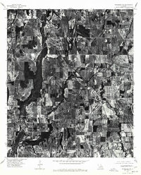 1976 Winnsboro SW1977 Print · USGSFranklin Parish farmland and small-town life are visible in this mid-seventies aerial survey of the Louisiana delta. Researchers can trace the layout of Gilbert and Chase or follow the natural path of Deer Creek through the fields.
 - 1982 Map of Tallulah, 1983 Print
 1982 Tallulah1983 Print · USGSNortheast Louisiana in the early eighties was a landscape of intricate oxbow lakes and railroad towns. Researchers can trace the heritage of parish centers like Tallulah and Winnsboro, or locate rural landmarks near Yucatan Lake and the Illinois Central Gulf tracks.
 - 1983 Map of Gilbert, 1984 Print
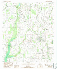 1983 Gilbert1984 Print · USGSFranklin Parish in the early 1980s reveals a landscape of tight-knit agricultural settlements and bayou drainages. Genealogists and local historians can trace family locations through numerous landmarks like Chase Cem, Wisner Jr High Sch, and Oakley Ch.
End of results
Showing maps 1-8 of 8
Top cities near Chase
- Winnsboro historical maps
- Wisner historical maps
- Mangham historical maps
- Gilbert historical maps
- Baskin historical maps
Frequently asked questions
- What are the different types of historical maps available for Chase?
- What is the oldest map of Chase?
- Where can I purchase historical maps of Chase for my home or office?
- Where can I download high-res historical maps of Chase?
- Are there historical topographic maps available for Chase?
- Is there historical aerial imagery available for Chase?
- Where are historical maps of Chase sourced from?