1900s (20th Century) Maps of Summerfield, Louisiana
Explore 7 historic maps of Summerfield from the 1900s (20th Century). These maps offer a rare glimpse into what life looked like during the 1900s — showing old roads, neighborhoods, homes, and landmarks that have changed or disappeared over time.
Whether you're researching your family's past, planning a metal detecting trip, or studying how Summerfield's landscape evolved across the 1900s, these high-resolution maps are a powerful tool for exploring the history of this region.
- Focus on a specific era: All maps on this page are from the 1900s, giving you a focused view of this time period.
- See what’s changed: Compare century-old streets, trails, and buildings to today's modern landscape using overlays and satellite layers.
- Research with precision: Use these maps for genealogy, historical research, land use analysis, or educational projects.
- View, download, or print: Maps are fully viewable online in high resolution, and can be downloaded or printed for your own records.
Start exploring Summerfield's history through authentic maps from the 1900s. This is your window into the past.
Summerfield, LA maps
(7)- 1932 Map of Colfax SW
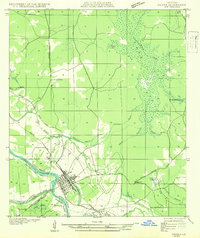 1932 Colfax SW1932 Print · USGSThe Red River valley of Central Louisiana is captured here in the early 1930s as a landscape of rail-connected settlements and complex waterways. Genealogists and historians can trace the foundations of Colfax and locate rural landmarks like Lee Chapel, Ferenzi Ch, and the Lutesville Gravel Pit.
 - 1936 Map of Colfax
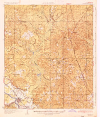 1936 Colfax1936 Print · USGSGrant Parish in the mid-1930s is defined by the sweeping course of the Red River and the expanding reaches of Lake Iatt. Local researchers can trace old family sites and rural institutions like Parsons Cem, Summerfield, and the Oak Grove Sch.2 unique versions available
 - 1953 Map of Alexandria, 1963 Print
 1953 Alexandria1963 Print · USGSCentral Louisiana during the early fifties is mapped here at the intersection of the piney woods and the Red River valley. Genealogists and historians can trace the rail-and-river network connecting towns like Alexandria, Natchitoches, and the grounds of Camp Beauregard.3 unique versions available
 - 1955 Map of Alexandria
 1955 Alexandria1955 Print · USGSCentral Louisiana in the mid-fifties is a landscape of river-port cities, sprawling timberlands, and massive military reservations. Genealogists and historians can trace the rail networks of the Texas & Pacific RR and locate sites like Camp Polk Military Reservation and Natchitoches.
 - 1956 Map of Colfax, 1957 Print
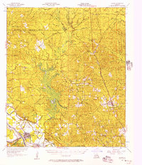 1956 Colfax1957 Print · USGSGrant and Winn Parishes come into focus during the mid-1950s, showing a landscape defined by forest reserves and rail-line settlements. Genealogists and historians can trace local roots through landmarks like Hebron Ch & Cem, Summerfield Sch, and McNeeley.3 unique versions available
 - 1985 Map of Colfax
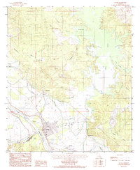 1985 Colfax1985 Print · USGSThe Red River valley in the mid-1980s reveals a landscape defined by its complex bayous and the growth of the parish seat at Colfax. Genealogists and historians can trace the footprints of Summerfield and Mc Neely or locate family markers at the local Cem.2 unique versions available
 - 1986 Map of Winnfield
 1986 Winnfield1986 Print · USGSCentral Louisiana in the mid-1980s was a landscape of timber towns and rail junctions woven through the Kisatchie National Forest. Researchers can trace the legacy of the lumber and rail eras through settlements like Good Pine, Packton, and Zenoria.2 unique versions available
End of results
Showing maps 1-7 of 7
Top cities near Summerfield
- Alexandria historical maps
- Colfax historical maps
- Boyce historical maps
- Montgomery historical maps
- Dry Prong historical maps
- Atlanta historical maps
Frequently asked questions
- What are the different types of historical maps available for Summerfield?
- What is the oldest map of Summerfield?
- Where can I purchase historical maps of Summerfield for my home or office?
- Where can I download high-res historical maps of Summerfield?
- Are there historical topographic maps available for Summerfield?
- Is there historical aerial imagery available for Summerfield?
- Where are historical maps of Summerfield sourced from?