Old Maps of Bucktown, Louisiana for Metal Detecting
Plan your next treasure hunt with 19 historic maps of Bucktown. Find old homesites, ghost towns, trails, and gathering spots that may be lost to time — perfect for identifying promising metal detecting locations.
- Locate forgotten sites: Uncover places like long-lost settlements, abandoned rail lines, or gathering spots.
- Plan better hunts: Use map overlays combined with LiDAR or satellite views to narrow in on historically rich areas.
- Made for detectorists: Thousands of hobbyists use these maps to discover relics, coins, and hidden history.
Use these historic maps to boost your research and find new opportunities beneath the surface of Bucktown.
Bucktown, LA maps
(19)- 1891 Map of Spanish Fort
 1891 Spanish Fort1891 Print · USGSThe New Orleans lakefront in the early 1890s was a landscape of emerging rail hubs and shoreline outposts. Trace the early footprints of Milneburg, Spanish Fort, and the lighthouse stations along Lake Pontchartrain during this pivotal era of coastal growth.4 unique versions available
 - 1936 Map of Spanish Fort, 1938 Print
 1936 Spanish Fort1938 Print · USGSThe New Orleans lakefront in the mid-1930s reveals a landscape of leisure and engineering as the city expanded toward the water. Trace the footprints of Pontchartrain Beach Amusement Park, the historic docks at Milneburg, and the path of the Old Spanish Trail.
 - 1938 Map of Indian Beach
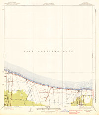 1938 Indian Beach1938 Print · USGSThe Jefferson Parish shoreline in the late 1930s reveals a landscape of early suburban growth defined by drainage canals and pumping stations. Researchers can trace the development of Bonnabel Place and the winding course of Bayou Tchoupitoulas near the southern edge of Lake Pontchartrain.3 unique versions available
 - 1952 Map of Indian Beach, 1953 Print
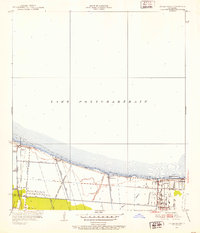 1952 Indian Beach1953 Print · USGSThe Jefferson Parish shoreline along Lake Pontchartrain is shown here during its mid-century transition to suburban development. Local historians can trace the early layouts of Indian Beach and Bucktown alongside the massive pumping and Carroll Canal systems that reclaimed this land.2 unique versions available
 - 1953 Map of Spanish Fort, 1954 Print
 1953 Spanish Fort1954 Print · USGSCoastal Jefferson and Orleans Parishes are shown in the early fifties during a period of significant drainage and airfield expansion. Researchers can trace the development of Metairie and West End or locate landmarks like Spanish Fort and the New Orleans Airport.
 - 1954 Map of Baton Rouge, 1974 Print
 1954 Baton Rouge1974 Print · USGSSoutheast Louisiana in the mid-fifties is captured here during a period of transition for its river and rail economies. Researchers can trace the path of the Mississippi River and find landmarks like the Bonnet Carre Spillway and Bayou Plaquemine.2 unique versions available
 - 1956 Map of Baton Rouge
 1956 Baton Rouge1956 Print · USGSSouth Louisiana at the height of the mid-century oil boom shows a landscape of river oxbows and rising industry. Researchers can trace family roots through river towns like Scotlandville or locate early industrial sites and Oil wells near Lake Maurepas.
 - 1961 Map of Baton Rouge, 1966 Print
 1961 Baton Rouge1966 Print · USGSSoutheastern Louisiana in the early sixties remains a landscape of deep river bends and sprawling coastal lakes. Genealogists and historians can trace the rail-and-river economy through landmarks like Free-Nigger Point, Donaldsonville, and the Illinois Central Railroad.
 - 1962 Map of Baton Rouge
 1962 Baton Rouge1962 Print · USGSSouth Louisiana in the early sixties reveals a landscape of river-bend parishes and emerging interstate corridors. Genealogists and historians can trace family roots through historic river towns like Donaldsonville and Plaquemine, or follow the path of the Illinois Central Railroad through the swamp basins.
 - 1965 Map of Indian Beach, 1966 Print
 1965 Indian Beach1966 Print · USGSJefferson Parish residential growth and critical levee engineering are on display in the mid-sixties. Researchers can trace neighborhood development in Bissonet Plaza and Indian Beach or locate landmarks like the Old Courthouse.4 unique versions available
 - 1967 Map of Spanish Fort, 1969 Print
 1967 Spanish Fort1969 Print · USGSThe Jefferson and Orleans Parish lakefronts are shown here in the late sixties as suburban expansion reached the shores of Lake Pontchartrain. Trace the development of neighborhoods like Bucktown and Indian Beach alongside the New Orleans Lakefront Airport.
 - 1983 Map of Ponchatoula, 1984 Print
 1983 Ponchatoula1984 Print · USGSThe Lake Pontchartrain Basin and the River Parishes come into focus during the early 1980s, showcasing the region's complex water-dependent geography. Researchers can trace the rail routes of the Illinois Central Gulf Railroad and explore landmarks from Pass Manchac to Donaldsonville.2 unique versions available
 - 1992 Map of Indian Beach
 1992 Indian Beach1992 Print · USGSThe Jefferson Parish shoreline in the early nineties shows the dense growth of suburban New Orleans behind a network of essential pumping stations and canals. Trace local landmarks from Jefferson Downs Racetrack to the older neighborhoods of Bucktown and Bonnabel Place.
 - 1998 Map of Indian Beach, 2002 Print
 1998 Indian Beach2002 Print · USGSJefferson Parish at the close of the nineties reveals a dense suburban landscape engineered against the waters of Lake Pontchartrain. Trace local landmarks like the Jefferson Downs Racetrack, the Lake Pontchartrain Causeway, and the neighborhood streets of Bucktown and Bissonet Plaza.
 - 2012 Map of Indian Beach, 2012 Print
 2012 Indian Beach2012 Print · USGSCovers Bucktown, including Kenner, Indian Beach, and other nearby areas
 - 2015 Map of Indian Beach, 2015 Print
 2015 Indian Beach2015 Print · USGSCovers Bucktown, including Kenner, Indian Beach, and other nearby areas
 - 2018 Map of Indian Beach, 2018 Print
 2018 Indian Beach2018 Print · USGSCovers Bucktown, including Kenner, Indian Beach, and other nearby areas
 - 2020 Map of Indian Beach, 2020 Print
 2020 Indian Beach2020 Print · USGSCovers Bucktown, including Kenner, Indian Beach, and other nearby areas
 - 2024 Map of Indian Beach, 2024 Print
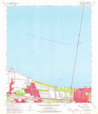
 2024 Indian Beach2024 Print · USGSJefferson Parish's northern lakefront comes into focus in this contemporary survey of the Louisiana coast. Genealogists and local historians can trace the street-level detail of residential neighborhoods like Bucktown, Indian Beach, and the community surrounding Herzing College.
End of results
Showing maps 1-19 of 19
Top cities near Bucktown
- New Orleans historical maps
- Metairie historical maps
- Kenner historical maps
- Algiers historical maps
- Chalmette historical maps
- Gretna historical maps
See more
Frequently asked questions
- What are the different types of historical maps available for Bucktown?
- What is the oldest map of Bucktown?
- Where can I purchase historical maps of Bucktown for my home or office?
- Where can I download high-res historical maps of Bucktown?
- Are there historical topographic maps available for Bucktown?
- Is there historical aerial imagery available for Bucktown?
- Where are historical maps of Bucktown sourced from?