1940s Maps of Manila Plaza, Jean Lafitte
Explore 3 historic maps of Manila Plaza from the 1940s. These maps offer a rare glimpse into what life looked like during the 1940s — showing old roads, neighborhoods, homes, and landmarks that have changed or disappeared over time.
Whether you're researching your family's past, planning a metal detecting trip, or studying how Manila Plaza's landscape evolved across the 1940s, these high-resolution maps are a powerful tool for exploring the history of this region.
- Focus on a specific era: All maps on this page are from the 1940s, giving you a focused view of this time period.
- See what’s changed: Compare century-old streets, trails, and buildings to today's modern landscape using overlays and satellite layers.
- Research with precision: Use these maps for genealogy, historical research, land use analysis, or educational projects.
- View, download, or print: Maps are fully viewable online in high resolution, and can be downloaded or printed for your own records.
Start exploring Manila Plaza's history through authentic maps from the 1940s. This is your window into the past.
Manila Plaza, Jean Lafitte maps
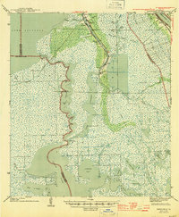
(3)- 1941 Map of Barataria
 1941 Barataria1941 Print · USGSCoastal Jefferson Parish appears at the dawn of the 1940s, where the Mississippi River meets a vast network of bayous and wetlands. Genealogists can trace family roots in Barataria and Jesuit Bend, or locate historic local landmarks like Fisher Sch No 1 and the Lafitte P O.
 - 1944 Map of Barataria
 1944 Barataria1944 Print · USGSCoastal Jefferson Parish appears as a intricate network of tidal bayous and marshes in the years during World War II. Genealogists and historians can trace the early settlement footprints of Lafitte P O, Villere, and the local Fisher Sch No 1.
 - 1945 Map of New Orleans
 1945 New Orleans1945 Print · USGSCoastal Louisiana and the Mississippi delta are captured here just after the war, showing the region's transition into a modern industrial and transit hub. Genealogists can trace family settlements along Bayou Teche or identify rail stops for the Illinois Central and Texas & Pacific lines.
End of results
Showing maps 1-3 of 3
Frequently asked questions
- What are the different types of historical maps available for Manila Plaza?
- What is the oldest map of Manila Plaza?
- Where can I purchase historical maps of Manila Plaza for my home or office?
- Where can I download high-res historical maps of Manila Plaza?
- Are there historical topographic maps available for Manila Plaza?
- Is there historical aerial imagery available for Manila Plaza?
- Where are historical maps of Manila Plaza sourced from?