1990s Maps of Choudrant, Louisiana
Explore 2 historic maps of Choudrant from the 1990s. These maps offer a rare glimpse into what life looked like during the 1990s — showing old roads, neighborhoods, homes, and landmarks that have changed or disappeared over time.
Whether you're researching your family's past, planning a metal detecting trip, or studying how Choudrant's landscape evolved across the 1990s, these high-resolution maps are a powerful tool for exploring the history of this region.
- Focus on a specific era: All maps on this page are from the 1990s, giving you a focused view of this time period.
- See what’s changed: Compare century-old streets, trails, and buildings to today's modern landscape using overlays and satellite layers.
- Research with precision: Use these maps for genealogy, historical research, land use analysis, or educational projects.
- View, download, or print: Maps are fully viewable online in high resolution, and can be downloaded or printed for your own records.
Start exploring Choudrant's history through authentic maps from the 1990s. This is your window into the past.
Choudrant, LA maps
(2)- 1994 Map of Ruston East, 1995 Print
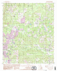 1994 Ruston East1995 Print · USGSLincoln Parish in the mid-1990s shows the growth of Ruston and its connections to the rural community of Choudrant. Trace local history through land use features like the Clay Pit and Sand Pits alongside winding waterways like Squire Creek.
 - 1994 Map of Downsville South, 1995 Print
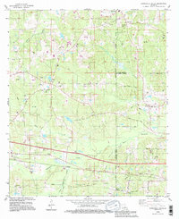 1994 Downsville South1995 Print · USGSLincoln Parish at the end of the twentieth century shows a landscape defined by its timbered hills and the expanding gas industry. Genealogists and local historians can locate several family landmarks and congregations, including Lanes Chapel Cems, the Saints Rest Ch Cem, and the community at Sibley.
End of results
Showing maps 1-2 of 2
Top cities near Choudrant
- Ruston historical maps
- Grambling historical maps
- Farmerville historical maps
- Dubach historical maps
- Vienna historical maps
- Eros historical maps
See more
Top neighborhoods of Choudrant
Frequently asked questions
- What are the different types of historical maps available for Choudrant?
- What is the oldest map of Choudrant?
- Where can I purchase historical maps of Choudrant for my home or office?
- Where can I download high-res historical maps of Choudrant?
- Are there historical topographic maps available for Choudrant?
- Is there historical aerial imagery available for Choudrant?
- Where are historical maps of Choudrant sourced from?