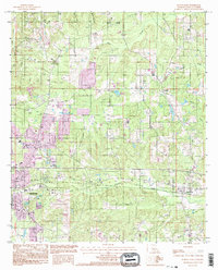
1994 Map of Ruston East
USGS Topo · Published 1995About this map
Ruston anchors the western edge of this mid-1990s survey, showing the city's eastern expansion toward the smaller settlement of Choudrant. The landscape is defined by the drainage basins of Choudrant Creek and Squire Creek, which meander through a mix of timberland and developing residential plots. Industrial footprints are visible in the form of several Sand Pits and a dedicated Clay Pit, reflecting the area's geological utility beyond agriculture. North of the city, the unincorporated community of Douglas sits near the headwaters of Cypress Creek, while the Ruston Regional Airport provides a significant modern landmark. This provisional map incorporates photography-based revisions that capture the infrastructure of Lincoln Parish before the turn of the millennium, including the corridors of Interstate 20 and the intersecting township and range lines that structured early Louisiana land claims.
Find a feature on this map
17 named features on this map. Tap any name to fly to it.
Don’t see what you’re looking for? This feature index may not catch every label — zoom into the map to look around manually.
Map Details
Editions of this 1994 Ruston East Map
This is the sole edition of this map. No revisions or reprints were ever made.
Other maps of this area

1950 · Ruston
USGS Topo · 1:62,500

1951 · Ruston
USGS Topo · 1:62,500

1952 · Calhoun
USGS Topo · 1:62,500

1953 · Chatham
USGS Topo · 1:62,500

1953 · Hodge
USGS Topo · 1:62,500

1955 · Shreveport
USGS Topo · 1:250,000

1956 · Shreveport
USGS Topo · 1:250,000
1982 · Downsville North
USGS Topo · 1:24,000
1982 · Eros
USGS Topo · 1:24,000
1982 · Downsville South
USGS Topo · 1:24,000