
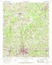
1950 Map of Ruston
USGS Topo · Published 1956About this map
Grambling College and the growing city of Ruston anchor the southern landscape of this mid-century survey, illustrating a period of significant educational and infrastructure expansion in Lincoln Parish. The Illinois Central and the Chicago Rock Island and Pacific railroads intersect at Ruston, which serves as a central hub for the surrounding timber and agricultural lands. Northward, the terrain is marked by smaller settlements like Dubach and Vienna, interspersed with numerous country schools such as Woody Sch and Macedonia Sch that once served these rural communities.
Find a feature on this map
73 named features on this map. Tap any name to fly to it.
Don’t see what you’re looking for? This feature index may not catch every label — zoom into the map to look around manually.
Map Details
Editions of this 1950 Ruston Map
2 editions found
Other maps of this area

1947 · Bienville
USGS Topo · 1:62,500

1949 · Bienville
USGS Topo · 1:62,500

1950 · Arcadia
USGS Topo · 1:62,500

1951 · Arcadia
USGS Topo · 1:62,500

1951 · Ruston
USGS Topo · 1:62,500

1951 · Summerfield
USGS Topo · 1:62,500

1951 · Bernice
USGS Topo · 1:62,500

1952 · Calhoun
USGS Topo · 1:62,500

1952 · Farmerville
USGS Topo · 1:62,500

1953 · Chatham
USGS Topo · 1:62,500