1956 Map of Shreveport
USGS Topo · Published 1956About this map
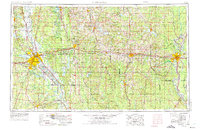
Shreveport and Monroe anchor this mid-1950s study of Northern Louisiana, a landscape defined by an extensive network of petroleum and natural gas production. The map meticulously documents the spatial relationship between industrial extraction and public lands, showing the massive Monroe Gas Field stretching toward the Ouachita River and the Haynesville Oil Field near the Arkansas border. Military and strategic infrastructure is prominent, including Barksdale Air Force Base and the Louisiana Ordnance Plant. Between these hubs of activity, the Illinois Central railroad connects smaller settlements like Minden, Ruston, and Arcadia. Conservation areas such as the Kisatchie National Forest and the Lake Bistineau State Game and Fish Preserve provide a counterpoint to the intensive industrial development of the era.
Find a feature on this map
139 named features on this map. Tap any name to fly to it.
Don’t see what you’re looking for? This feature index may not catch every label — zoom into the map to look around manually.
Map Details
Editions of this 1956 Shreveport Map
This is the sole edition of this map. No revisions or reprints were ever made.
Historical Maps of Shreveport Through Time
3 maps found