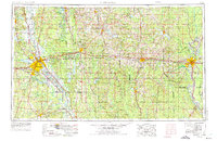
1955 Map of Shreveport
USGS Topo · Published 1975About this map
The Red River corridor defines the western landscape of this mid-century survey, anchoring the growing urban centers of Shreveport and Bossier City. This era shows a region balancing heavy industrial and military infrastructure with vast timber and recreational lands. To the east of the city, Barksdale Air Force Base and the Louisiana Ordnance Plant represent the massive federal footprint in the area during the early Cold War years. The northern and central portions are heavily forested, home to portions of the Kisatchie National Forest and the newly established D'Arbonne Lake. Significant educational institutions like Louisiana Tech University in Ruston and Grambling State University appear alongside an intricate rail network, including the Illinois Central Railroad and the Kansas City Southern Railway. From the bayous of Caddo Parish to the Ouachita River at Monroe, the map captures North Louisiana's transition from a rural, river-based economy to a modern industrial and transportation hub.
Find a feature on this map
171 named features on this map. Tap any name to fly to it.
Don’t see what you’re looking for? This feature index may not catch every label — zoom into the map to look around manually.
Map Details
Editions of this 1955 Shreveport Map
3 editions found

Other maps of this area

1907 · Atlanta
USGS Topo · 1:62,500

1910 · Atlanta
USGS Topo · 1:62,500

1922 · Sarepta
USGS Topo · 1:62,500

1924 · Sarepta
USGS Topo · 1:62,500

1927 · El Dorado
USGS Topo · 1:62,500

1930 · El Dorado
USGS Topo · 1:62,500

1932 · Hosston NW
USGS Topo · 1:31,680

1932 · Bossier SE
USGS Topo · 1:31,680

1932 · Hosston NE
USGS Topo · 1:31,680

1932 · Bossier NE
USGS Topo · 1:31,680