Loading...
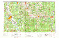
Loading map...1955 Map of Shreveport
USGS Topo · Published 1966About this map
The Red River corridor defines the western edge of this mid-century survey, anchoring a landscape where major military installations and industrial energy fields intersect. To the east of Shreveport, Barksdale Air Force Base and the Louisiana Ordnance Plant represent a significant federal footprint in the region. The map captures North Louisiana during a period of intense resource extraction, evidenced by the expansive Monroe Gas Field and numerous oil developments like the Rodessa Oil Field and Haynesville Oil Field.
Find a feature on this map
234 named features on this map. Tap any name to fly to it.
Don’t see what you’re looking for? This feature index may not catch every label — zoom into the map to look around manually.
Map Details
Date Portrayed1955
Date Published1966
PublisherU.S. Geological Survey
Map TypeTopographic
Scale1:250,000
Physical Dimensions34.2 x 22 inches
Editions of this 1955 Shreveport Map
3 editions found

Historical Maps of Shreveport Through Time
3 maps found


Featured Locations
Source Details
SourceU.S. Geological Survey
CopyrightPublic Domain