1950s Maps of Normay-Ray, Ruston
Explore 4 historic maps of Normay-Ray from the 1950s. These maps offer a rare glimpse into what life looked like during the 1950s — showing old roads, neighborhoods, homes, and landmarks that have changed or disappeared over time.
Whether you're researching your family's past, planning a metal detecting trip, or studying how Normay-Ray's landscape evolved across the 1950s, these high-resolution maps are a powerful tool for exploring the history of this region.
- Focus on a specific era: All maps on this page are from the 1950s, giving you a focused view of this time period.
- See what’s changed: Compare century-old streets, trails, and buildings to today's modern landscape using overlays and satellite layers.
- Research with precision: Use these maps for genealogy, historical research, land use analysis, or educational projects.
- View, download, or print: Maps are fully viewable online in high resolution, and can be downloaded or printed for your own records.
Start exploring Normay-Ray's history through authentic maps from the 1950s. This is your window into the past.
Normay-Ray, Ruston maps
(4)- 1950 Map of Ruston, 1956 Print
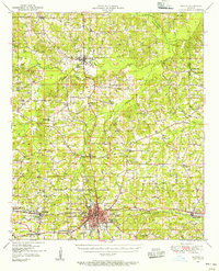 1950 Ruston1956 Print · USGSLincoln Parish at mid-century centers on the expansion of Ruston and the campus of Grambling College during a period of steady growth. Researchers can trace rural lineages through numerous country landmarks like New Prospect Ch, Macedonia Cem, and Culbertson Sch.2 unique versions available
 - 1951 Map of Ruston
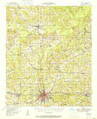 1951 Ruston1951 Print · USGSNorth Louisiana in the early fifties was a landscape of rail-driven towns and deep-rooted rural parishes. Genealogists can trace family landmarks like Henry Cem and Macedonia Ch, or explore the early campus footprint of Grambling College.
 - 1955 Map of Shreveport
 1955 Shreveport1955 Print · USGSNorthern Louisiana in the mid-fifties is captured here as a landscape of military bases, vast oil fields, and burgeoning college towns. Genealogists and historians can trace the rail-and-river economy through the Monroe Gas Field, Grambling College, and Barksdale Air Force Base.3 unique versions available
 - 1956 Map of Shreveport
 1956 Shreveport1956 Print · USGSNorthern Louisiana during the mid-fifties presents a complex landscape of booming oil fields and strategic military installations. Genealogists and historians can trace the infrastructure of the Monroe Gas Field and family-named locales from Cotton Valley to Jonesboro.
End of results
Showing maps 1-4 of 4
Frequently asked questions
- What are the different types of historical maps available for Normay-Ray?
- What is the oldest map of Normay-Ray?
- Where can I purchase historical maps of Normay-Ray for my home or office?
- Where can I download high-res historical maps of Normay-Ray?
- Are there historical topographic maps available for Normay-Ray?
- Is there historical aerial imagery available for Normay-Ray?
- Where are historical maps of Normay-Ray sourced from?