1940s Maps of Natchitoches, Louisiana
Explore 4 historic maps of Natchitoches from the 1940s. These maps offer a rare glimpse into what life looked like during the 1940s — showing old roads, neighborhoods, homes, and landmarks that have changed or disappeared over time.
Whether you're researching your family's past, planning a metal detecting trip, or studying how Natchitoches's landscape evolved across the 1940s, these high-resolution maps are a powerful tool for exploring the history of this region.
- Focus on a specific era: All maps on this page are from the 1940s, giving you a focused view of this time period.
- See what’s changed: Compare century-old streets, trails, and buildings to today's modern landscape using overlays and satellite layers.
- Research with precision: Use these maps for genealogy, historical research, land use analysis, or educational projects.
- View, download, or print: Maps are fully viewable online in high resolution, and can be downloaded or printed for your own records.
Start exploring Natchitoches's history through authentic maps from the 1940s. This is your window into the past.
Natchitoches, LA maps
(4)- 1943 Map of Provencal, 1954 Print
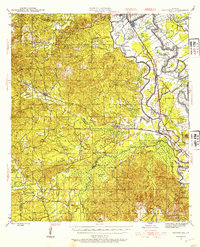 1943 Provencal1954 Print · USGSNatchitoches Parish during the early 1940s reveals a landscape defined by the winding Red River and the Texas and Pacific RR. Genealogists can trace rural roots through landmarks like Friendship Cem, St Marks Ch, and the community at Bermuda.
 - 1944 Map of Campti, 1955 Print
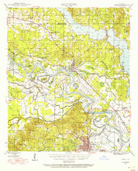 1944 Campti1955 Print · USGSNatchitoches and the Red River valley are shown here during the mid-1940s, highlighting a landscape of river bends and rail-dependent settlements. Researchers can trace family roots through numerous country landmarks like Bethlehem Sch, St Lukes Cem, and the river port at Grand Ecore.
 - 1945 Map of Provencal
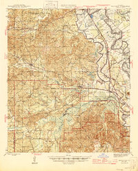 1945 Provencal1945 Print · USGSNatchitoches Parish during the mid-1940s is defined by its complex network of waterways and the Texas and Pacific RR. Researchers can locate rural landmarks like Rockford Sch, Beasley Crossing, and the Bayou Gorum Post Office.
 - 1948 Map of Campti
 1948 Campti1948 Print · USGSNatchitoches Parish and the Red River valley are captured in the late 1940s, showing a landscape defined by oxbows and rural life. Researchers can trace historic schools and churches from Campti to Powhatan, including Bethel Cem and Grappes Bluff.2 unique versions available
End of results
Showing maps 1-4 of 4
Top cities near Natchitoches
- Campti historical maps
- Montgomery historical maps
- Natchez historical maps
- Provencal historical maps
- Clarence historical maps
- Robeline historical maps
See more
Top neighborhoods of Natchitoches
Frequently asked questions
- What are the different types of historical maps available for Natchitoches?
- What is the oldest map of Natchitoches?
- Where can I purchase historical maps of Natchitoches for my home or office?
- Where can I download high-res historical maps of Natchitoches?
- Are there historical topographic maps available for Natchitoches?
- Is there historical aerial imagery available for Natchitoches?
- Where are historical maps of Natchitoches sourced from?