1930s Maps of Algiers Point, New Orleans
Explore 2 historic maps of Algiers Point from the 1930s. These maps offer a rare glimpse into what life looked like during the 1930s — showing old roads, neighborhoods, homes, and landmarks that have changed or disappeared over time.
Whether you're researching your family's past, planning a metal detecting trip, or studying how Algiers Point's landscape evolved across the 1930s, these high-resolution maps are a powerful tool for exploring the history of this region.
- Focus on a specific era: All maps on this page are from the 1930s, giving you a focused view of this time period.
- See what’s changed: Compare century-old streets, trails, and buildings to today's modern landscape using overlays and satellite layers.
- Research with precision: Use these maps for genealogy, historical research, land use analysis, or educational projects.
- View, download, or print: Maps are fully viewable online in high resolution, and can be downloaded or printed for your own records.
Start exploring Algiers Point's history through authentic maps from the 1930s. This is your window into the past.
Algiers Point, New Orleans maps
(2)- 1932 Map of New Orleans NE
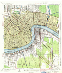
 1932 New Orleans NE1932 Print · USGSNew Orleans and the West Bank riverfront are seen in the early thirties, showing the dense grid of the French Quarter and the sprawling medical and university districts. Researchers can find old landmarks like St Louis Cathedral, the Custom House, and Gretna High School.
 - 1939 Map of New Orleans East
 1939 New Orleans East1939 Print · USGSThe crescent city and its surrounding river parishes are captured in the late 1930s, showing New Orleans' transition into a modern port and educational hub. Genealogists can trace family roots through neighborhoods like Algiers and Arabi, or locate ancestors in St Louis Cem and Metairie Cemetery.3 unique versions available
End of results
Showing maps 1-2 of 2
Top cities near Algiers Point
- New Orleans historical maps
- Metairie historical maps
- Kenner historical maps
- Algiers historical maps
- Chalmette historical maps
- Gretna historical maps
See more
Frequently asked questions
- What are the different types of historical maps available for Algiers Point?
- What is the oldest map of Algiers Point?
- Where can I purchase historical maps of Algiers Point for my home or office?
- Where can I download high-res historical maps of Algiers Point?
- Are there historical topographic maps available for Algiers Point?
- Is there historical aerial imagery available for Algiers Point?
- Where are historical maps of Algiers Point sourced from?