1990s Maps of Buras, Louisiana
Explore 2 historic maps of Buras from the 1990s. These maps offer a rare glimpse into what life looked like during the 1990s — showing old roads, neighborhoods, homes, and landmarks that have changed or disappeared over time.
Whether you're researching your family's past, planning a metal detecting trip, or studying how Buras's landscape evolved across the 1990s, these high-resolution maps are a powerful tool for exploring the history of this region.
- Focus on a specific era: All maps on this page are from the 1990s, giving you a focused view of this time period.
- See what’s changed: Compare century-old streets, trails, and buildings to today's modern landscape using overlays and satellite layers.
- Research with precision: Use these maps for genealogy, historical research, land use analysis, or educational projects.
- View, download, or print: Maps are fully viewable online in high resolution, and can be downloaded or printed for your own records.
Start exploring Buras's history through authentic maps from the 1990s. This is your window into the past.
Buras, LA maps
(2)- 1993 Map of Buras, 1994 Print
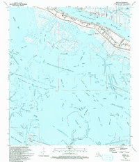 1993 Buras1994 Print · USGSThe Mississippi Delta's fragile landscape is documented here in the early nineties, showing the town of Buras squeezed between the river levee and the marsh. Researchers can trace local infrastructure from the Buras Boat Harbor to the Cem and High Sch.
 - 1998 Map of Buras, 2003 Print
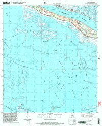 1998 Buras2003 Print · USGSThe Plaquemines Parish coast in the late nineties is defined by the narrow levee-protected settlements along the Mississippi River. Genealogists and historians can trace the community layout of Buras, locate the High Sch Cem, and study the energy infrastructure of the West Bastian Bay Oil and Gas Field.
End of results
Showing maps 1-2 of 2
Top cities near Buras
Frequently asked questions
- What are the different types of historical maps available for Buras?
- What is the oldest map of Buras?
- Where can I purchase historical maps of Buras for my home or office?
- Where can I download high-res historical maps of Buras?
- Are there historical topographic maps available for Buras?
- Is there historical aerial imagery available for Buras?
- Where are historical maps of Buras sourced from?