Old Maps of Deer Range, Louisiana for Academic Research
Study the evolution of Deer Range with 16 high-resolution historic maps. Whether you're teaching, researching, or modeling changes in land use, these maps provide essential visual documentation of urban, environmental, and geographic change.
- Analyze long-term change: Track patterns in development, transportation, and natural features.
- Ideal for environmental or urban studies: Support academic projects with primary historical map data.
- Use in the classroom or lab: Educators and researchers rely on these maps to bring historical context to life.
These maps are a powerful tool for teaching, research, and visualizing how Deer Range has changed over the decades.
Deer Range, LA maps
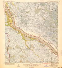
(16)- 1891 Map of Pointe a La Hache
 1891 Pointe a La Hache1891 Print · USGSCoastal Plaquemines Parish and the Mississippi River delta appear here in the early 1890s, revealing a landscape of narrow riverfront plantations and rail-connected settlements. Researchers can trace the path of the New Orleans Ft Jackson and Grand Isl Railroad through historic sites like Pt A La Hache, Myrtle Grove, and Empire Mills.
 - 1892 Map of Pointe a La Hache, 1898 Print
 1892 Pointe a La Hache1898 Print · USGSThe lower Mississippi delta in the 1890s reveals a ribbon of riverfront settlements and competing rail lines. Genealogists and historians can trace family-named sites like Savoie and Nero or locate the Empire Mills (Martin) near Pt. A La Hache.
 - 1939 Map of Pointe a La Hache, 1941 Print
 1939 Pointe a La Hache1941 Print · USGSCoastal Plaquemines Parish centers on the riverbank communities of the late thirties, when the local economy was tied to the water and the rail. Researchers can trace the legacy of family settlements and rural institutions like the Deer Range Cem, St Jude Sch, and the rail lines at Pte Celeste.2 unique versions available
 - 1944 Map of Pointe a La Hache
 1944 Pointe a La Hache1944 Print · USGSThe Mississippi River delta in the early 1940s shows a landscape of rail-connected river towns and vast marshlands. Trace family roots and local history through Deer Range Cem, St Jude Sch, and settlements like Pointe a la Hache.
 - 1948 Map of Pointe a La Hache, 1951 Print
 1948 Pointe a La Hache1951 Print · USGSIn the late 1940s, the Mississippi River delta was a landscape of levee-side settlements and growing oil fields. Trace family history through riverfront outposts like Pointe a la Hache, the St Jude Sch (Colored) & Cem, and Beanbury Plantation.
 - 1957 Map of Breton Sound, 1967 Print
 1957 Breton Sound1967 Print · USGSThe Mississippi River delta is captured here in the mid-fifties, showing the fragile marshlands and river-dependent towns of the Louisiana coast. Genealogists and historians can trace riverside settlements like Pointe a la Hache, Pilottown, and Port Sulphur.3 unique versions available
 - 1961 Map of Breton Sound
 1961 Breton Sound1961 Print · USGSThe Louisiana delta and the outer marshes of Plaquemines Parish are captured here at the start of the 1960s. Researchers can trace the river settlements from Davant to Venice, locate isolated stations like Port Eads, and find old sites such as Fort Jackson.
 - 1962 Map of Pointe a La Hache, 1966 Print
 1962 Pointe a La Hache1966 Print · USGSCoastal Plaquemines Parish reveals a landscape of river-dependent towns and delta marshes in the early sixties. Genealogists can trace family roots through riverside sites like Carlisle P O, Besumar Plantation, and the Seichsnaydre Cem.
 - 1964 Map of Pointe a La Hache, 1965 Print
 1964 Pointe a La Hache1965 Print · USGSCoastal Louisiana at the height of the mid-century oil boom centers on the communities flanking the Mississippi River. Genealogists and historians can trace family roots through riverfront landmarks like Beaumar Plantation, Pointe a la Hache, and the St Jude Sch & Ch.
 - 1973 Map of Lake Laurier, 1976 Print
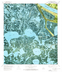 1973 Lake Laurier1976 Print · USGSThe Plaquemines Parish delta in the early 1970s reveals a landscape where river industry meets the deep marsh. Genealogists and historians can trace riverside settlements like Bellevue and Deer Range or locate the Deer Range Cem near the Mississippi River levee.2 unique versions available
 - 1983 Map of Black Bay
 1983 Black Bay1983 Print · USGSCoastal St. Bernard Parish is shown in the early eighties as the Mississippi Delta's fishing villages and industrial infrastructure meet the expanding Gulf sounds. Genealogists and historians can trace family-named sites from Chalmette to Delacroix, including the Southern Railway System and St Bernard State Park.2 unique versions available
 - 2012 Map of Lake Laurier, 2012 Print
 2012 Lake Laurier2012 Print · USGSCovers Deer Range, including Bellevue, Harlem, and other nearby areas
 - 2015 Map of Lake Laurier, 2015 Print
 2015 Lake Laurier2015 Print · USGSCovers Deer Range, including Bellevue, Harlem, and other nearby areas
 - 2018 Map of Lake Laurier, 2018 Print
 2018 Lake Laurier2018 Print · USGSCovers Deer Range, including Bellevue, Harlem, and other nearby areas
 - 2020 Map of Lake Laurier, 2020 Print
 2020 Lake Laurier2020 Print · USGSCovers Deer Range, including Bellevue, Harlem, and other nearby areas
 - 2024 Map of Lake Laurier, 2024 Print
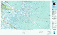
 2024 Lake Laurier2024 Print · USGSPlaquemines Parish settlements hug the banks of the Mississippi River in this 2024 survey of the Louisiana wetlands. Genealogists and local historians can trace the riverside communities of Harlem and Deer Range, or locate the Deer Range Cem.
End of results
Showing maps 1-16 of 16
Top cities near Deer Range
Frequently asked questions
- What are the different types of historical maps available for Deer Range?
- What is the oldest map of Deer Range?
- Where can I purchase historical maps of Deer Range for my home or office?
- Where can I download high-res historical maps of Deer Range?
- Are there historical topographic maps available for Deer Range?
- Is there historical aerial imagery available for Deer Range?
- Where are historical maps of Deer Range sourced from?