1950s Maps of English Turn, Louisiana
Explore 3 historic maps of English Turn from the 1950s. These maps offer a rare glimpse into what life looked like during the 1950s — showing old roads, neighborhoods, homes, and landmarks that have changed or disappeared over time.
Whether you're researching your family's past, planning a metal detecting trip, or studying how English Turn's landscape evolved across the 1950s, these high-resolution maps are a powerful tool for exploring the history of this region.
- Focus on a specific era: All maps on this page are from the 1950s, giving you a focused view of this time period.
- See what’s changed: Compare century-old streets, trails, and buildings to today's modern landscape using overlays and satellite layers.
- Research with precision: Use these maps for genealogy, historical research, land use analysis, or educational projects.
- View, download, or print: Maps are fully viewable online in high resolution, and can be downloaded or printed for your own records.
Start exploring English Turn's history through authentic maps from the 1950s. This is your window into the past.
English Turn, LA maps
(3)- 1951 Map of Chalmette, 1953 Print
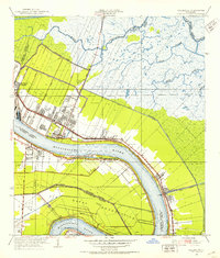 1951 Chalmette1953 Print · USGSCoastal St. Bernard Parish comes to life in the early fifties as suburban growth meets the industrial riverfront. Genealogists and historians can trace family locations in Fazandeville, Stanton, and Meraux or locate the Chalmette Nat Cem.2 unique versions available
 - 1955 Map of St. Bernard
 1955 St. Bernard1955 Print · USGSCoastal Louisiana in the mid-fifties reveals a landscape defined by river commerce and expansive marshlands. Genealogists and historians can trace family-named sites and landmarks like True Love Cemetery, Pakenham Oaks, and the Martello Tower.
 - 1957 Map of Breton Sound, 1967 Print
 1957 Breton Sound1967 Print · USGSThe Mississippi River delta is captured here in the mid-fifties, showing the fragile marshlands and river-dependent towns of the Louisiana coast. Genealogists and historians can trace riverside settlements like Pointe a la Hache, Pilottown, and Port Sulphur.3 unique versions available
End of results
Showing maps 1-3 of 3
Top cities near English Turn
- New Orleans historical maps
- Metairie historical maps
- Algiers historical maps
- Chalmette historical maps
- Gretna historical maps
- Westwego historical maps
See more
Frequently asked questions
- What are the different types of historical maps available for English Turn?
- What is the oldest map of English Turn?
- Where can I purchase historical maps of English Turn for my home or office?
- Where can I download high-res historical maps of English Turn?
- Are there historical topographic maps available for English Turn?
- Is there historical aerial imagery available for English Turn?
- Where are historical maps of English Turn sourced from?