Old Maps of Hot Wells, Louisiana for Hiking & Exploration
Hike through history with 13 historic maps of Hot Wells. Explore old trails, ghost towns, and forgotten backroads — perfect for outdoor adventurers and local explorers.
- Rediscover forgotten places: Map out old mining camps, roads, and footpaths that no longer exist on modern maps.
- Layer with modern tools: Combine with LiDAR or satellite views to plan hikes through historical terrain.
- Made for exploration: Popular among hikers, overlanders, and local history lovers.
Use these maps to find adventure and explore the hidden past of Hot Wells.
Hot Wells, LA maps
(13)- 1932 Map of Boyce SW
 1932 Boyce SW1932 Print · USGSRapides Parish in the early thirties is a landscape of rural post offices and emerging federal forests. Genealogists can trace family landmarks like the Texada Cem, Wilda Po, and local country schools such as Laurel Hill Sch.
 - 1941 Map of Boyce, 1945 Print
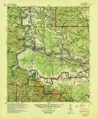 1941 Boyce1945 Print · USGSRapides Parish was a landscape of river plantations and pine forests in the early 1940s. Genealogists and historians can locate numerous rural landmarks like Hotwells, Fairmount Plantation, and the Israelite Ch Sch & Cem along the Red River.2 unique versions available
 - 1953 Map of Alexandria, 1963 Print
 1953 Alexandria1963 Print · USGSCentral Louisiana during the early fifties is mapped here at the intersection of the piney woods and the Red River valley. Genealogists and historians can trace the rail-and-river network connecting towns like Alexandria, Natchitoches, and the grounds of Camp Beauregard.3 unique versions available
 - 1955 Map of Alexandria
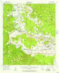
 1955 Alexandria1955 Print · USGSCentral Louisiana in the mid-fifties is a landscape of river-port cities, sprawling timberlands, and massive military reservations. Genealogists and historians can trace the rail networks of the Texas & Pacific RR and locate sites like Camp Polk Military Reservation and Natchitoches.
 - 1956 Map of Boyce, 1957 Print
 1956 Boyce1957 Print · USGSLouisiana's Red River valley in the mid-fifties reveals a landscape transitioning from traditional rail-and-river commerce to a burgeoning military presence. Trace family roots through dozens of rural sites like Hotwells, the Second Evening Star Ch, and Lacour Cem.3 unique versions available
 - 1971 Map of Gardner, 1974 Print
 1971 Gardner1974 Print · USGSRapides Parish was undergoing significant hydrological changes in the early seventies as new reservoirs took shape across the forest. Genealogists and historians can trace several family-named landmarks and rural congregations, from Texada Cem and McNutt Cem to the Hemphill Star Ch.3 unique versions available
 - 1986 Map of Alexandria
 1986 Alexandria1986 Print · USGSCentral Louisiana in the mid-eighties shows a landscape of strategic military installations and deep river-valley agriculture. Researchers can trace the footprints of England Air Force Base, Camp Beauregard, and the extensive Kisatchie National Forest.2 unique versions available
 - 2003 Map of Gardner, 2005 Print
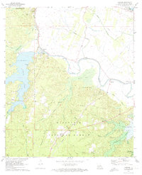
 2003 Gardner2005 Print · USGSRapides Parish at the start of the new millennium shows a landscape defined by the Kisatchie National Forest and expansive reservoirs. Researchers can trace family roots through historic sites like Campground Cem, Hot Wells, and Laurel Hill Ch.
 - 2012 Map of Gardner, 2012 Print
 2012 Gardner2012 Print · USGSCovers Hot Wells, including Quadrate, Wilda, and other nearby areas
 - 2015 Map of Gardner, 2015 Print
 2015 Gardner2015 Print · USGSCovers Hot Wells, including Quadrate, Wilda, and other nearby areas
 - 2018 Map of Gardner, 2018 Print
 2018 Gardner2018 Print · USGSCovers Hot Wells, including Quadrate, Wilda, and other nearby areas
 - 2020 Map of Gardner, 2020 Print
 2020 Gardner2020 Print · USGSCovers Hot Wells, including Quadrate, Wilda, and other nearby areas
 - 2024 Map of Gardner, 2024 Print
 2024 Gardner2024 Print · USGSRapides Parish in the current era shows a landscape of national forest and managed reservoirs alongside long-established rural settlements. Researchers can trace family history through numerous small burial grounds like Camp Ground Cem and Texada Cem or explore the drainage of Bayou Rapides.
End of results
Showing maps 1-13 of 13
Top cities near Hot Wells
Frequently asked questions
- What are the different types of historical maps available for Hot Wells?
- What is the oldest map of Hot Wells?
- Where can I purchase historical maps of Hot Wells for my home or office?
- Where can I download high-res historical maps of Hot Wells?
- Are there historical topographic maps available for Hot Wells?
- Is there historical aerial imagery available for Hot Wells?
- Where are historical maps of Hot Wells sourced from?