1900s (20th Century) Maps of Rayville, Louisiana
Explore 10 historic maps of Rayville from the 1900s (20th Century). These maps offer a rare glimpse into what life looked like during the 1900s — showing old roads, neighborhoods, homes, and landmarks that have changed or disappeared over time.
Whether you're researching your family's past, planning a metal detecting trip, or studying how Rayville's landscape evolved across the 1900s, these high-resolution maps are a powerful tool for exploring the history of this region.
- Focus on a specific era: All maps on this page are from the 1900s, giving you a focused view of this time period.
- See what’s changed: Compare century-old streets, trails, and buildings to today's modern landscape using overlays and satellite layers.
- Research with precision: Use these maps for genealogy, historical research, land use analysis, or educational projects.
- View, download, or print: Maps are fully viewable online in high resolution, and can be downloaded or printed for your own records.
Start exploring Rayville's history through authentic maps from the 1900s. This is your window into the past.
Rayville, LA maps
(10)- 1935 Map of Alto, 1936 Print
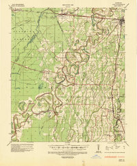 1935 Alto1936 Print · USGSRichland Parish in the mid-1930s shows a landscape of river-bottom agriculture and an early industrial energy boom. Researchers can trace the legacy of local river travel at Douciere Ferry and locate commercial sites like Rhymes Store or the Century Carbon Company.2 unique versions available
 - 1935 Map of Baskinton, 1936 Print
 1935 Baskinton1936 Print · USGSNortheast Louisiana in the mid-1930s is defined by its drainage basins and river landings between the rail towns of Rayville and Delhi. Genealogists can locate rural landmarks such as Hill Ridge Ch & Sch, Baskinton, and landings like Sunrise Ldg.
 - 1955 Map of Jackson
 1955 Jackson1955 Print · USGSThe Lower Mississippi Valley at the middle of the century reveals a landscape of deep river meanders and growing rail hubs. Genealogists and historians can trace the mid-century footprints of Vicksburg National Military Park, old river landings at Port Gibson, and the rail corridors of the Illinois Central Railroad.3 unique versions available
 - 1957 Map of Mangham, 1958 Print
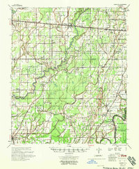
 1957 Mangham1958 Print · USGSRichland and Franklin Parishes in the late fifties reveal a landscape of river-bottom agriculture and small rail towns. Genealogists can trace family roots through numerous local landmarks like Rhymes High Sch, St Luke Cem, and Mt Zion Ch.3 unique versions available
 - 1958 Map of Baskinton
 1958 Baskinton1958 Print · USGSRichland and Franklin Parishes in the late fifties show a landscape transitioning between traditional bayou life and the post-war energy boom. Researchers can locate vanished rural landmarks like Hunters Chapel, the Delhi Refining Co, and old river stops like Indian Ldg.2 unique versions available
 - 1961 Map of Jackson
 1961 Jackson1961 Print · USGSThe Lower Mississippi Delta and the state capital area are captured here during the post-war era of infrastructure expansion. Researchers can trace the complex river oxbows and rail lines connecting Vicksburg, Yazoo City, and the Illinois Central Railroad network.
 - 1962 Map of Jackson
 1962 Jackson1962 Print · USGSThe Mississippi Delta and the state capital region are mapped here in the early sixties, showing a landscape defined by the great river and the growing city of JACKSON. Genealogists can trace family roots through numerous landmarks like Cedar Hill Cem, rural stops on the Illinois Central RR, and historic sites like Champion Hill.2 unique versions available
 - 1982 Map of Rayville, 1983 Print
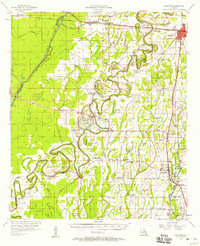
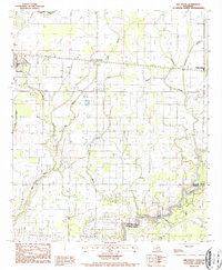
 1982 Rayville1983 Print · USGSRichland Parish in the early eighties centers on the rail junction at Rayville, where the Illinois Central Gulf meets the Bayou Boeuf bottomlands. Genealogists and historians can trace numerous rural landmarks like St Paul Ch, Masonic Cem, and the old settlement at Girard.
 - 1982 Map of Tallulah, 1983 Print
 1982 Tallulah1983 Print · USGSNortheast Louisiana in the early eighties was a landscape of intricate oxbow lakes and railroad towns. Researchers can trace the heritage of parish centers like Tallulah and Winnsboro, or locate rural landmarks near Yucatan Lake and the Illinois Central Gulf tracks.
 - 1987 Map of Bee Bayou
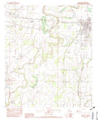
 1987 Bee Bayou1987 Print · USGSRichland Parish during the late 1980s reveals a landscape shaped by intricate bayous and the Illinois Central Gulf rail line. Genealogists and local historians can trace the rural tracts between Rayville and Holly Ridge near the banks of Bee Bayou.
End of results
Showing maps 1-10 of 10
Top cities near Rayville
Frequently asked questions
- What are the different types of historical maps available for Rayville?
- What is the oldest map of Rayville?
- Where can I purchase historical maps of Rayville for my home or office?
- Where can I download high-res historical maps of Rayville?
- Are there historical topographic maps available for Rayville?
- Is there historical aerial imagery available for Rayville?
- Where are historical maps of Rayville sourced from?