1980s Maps of Esto, Louisiana
Explore 2 historic maps of Esto from the 1980s. These maps offer a rare glimpse into what life looked like during the 1980s — showing old roads, neighborhoods, homes, and landmarks that have changed or disappeared over time.
Whether you're researching your family's past, planning a metal detecting trip, or studying how Esto's landscape evolved across the 1980s, these high-resolution maps are a powerful tool for exploring the history of this region.
- Focus on a specific era: All maps on this page are from the 1980s, giving you a focused view of this time period.
- See what’s changed: Compare century-old streets, trails, and buildings to today's modern landscape using overlays and satellite layers.
- Research with precision: Use these maps for genealogy, historical research, land use analysis, or educational projects.
- View, download, or print: Maps are fully viewable online in high resolution, and can be downloaded or printed for your own records.
Start exploring Esto's history through authentic maps from the 1980s. This is your window into the past.
Esto, LA maps
(2)- 1985 Map of Negreet
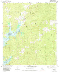 1985 Negreet1985 Print · USGSSabine Parish in the mid-1980s reveals a landscape transformed by the waters of the Toledo Bend Reservoir. Researchers can trace rural lineages through sites like Zion Hill Ch, Carroll Cem, and the small settlement of Negreet.
 - 1986 Map of Leesville, 1988 Print
 1986 Leesville1988 Print · USGSThe Louisiana-Texas borderlands in the mid-eighties centered on the vast Toledo Bend Reservoir and the timber-rich piney woods. Researchers can trace the Kansas City Southern RR corridor or locate old communities like Wiergate, Rosevine, and Sandel.
End of results
Showing maps 1-2 of 2
Top cities near Esto
- Many historical maps
- Hemphill historical maps
- Florien historical maps
- Hornbeck historical maps
- Fisher historical maps
Frequently asked questions
- What are the different types of historical maps available for Esto?
- What is the oldest map of Esto?
- Where can I purchase historical maps of Esto for my home or office?
- Where can I download high-res historical maps of Esto?
- Are there historical topographic maps available for Esto?
- Is there historical aerial imagery available for Esto?
- Where are historical maps of Esto sourced from?