1950s Maps of Boar's Tooth, Louisiana
Explore 3 historic maps of Boar's Tooth from the 1950s. These maps offer a rare glimpse into what life looked like during the 1950s — showing old roads, neighborhoods, homes, and landmarks that have changed or disappeared over time.
Whether you're researching your family's past, planning a metal detecting trip, or studying how Boar's Tooth's landscape evolved across the 1950s, these high-resolution maps are a powerful tool for exploring the history of this region.
- Focus on a specific era: All maps on this page are from the 1950s, giving you a focused view of this time period.
- See what’s changed: Compare century-old streets, trails, and buildings to today's modern landscape using overlays and satellite layers.
- Research with precision: Use these maps for genealogy, historical research, land use analysis, or educational projects.
- View, download, or print: Maps are fully viewable online in high resolution, and can be downloaded or printed for your own records.
Start exploring Boar's Tooth's history through authentic maps from the 1950s. This is your window into the past.
Boar's Tooth, LA maps
(3)- 1954 Map of Lake Eloi
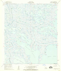
 1954 Lake Eloi1954 Print · USGSSt. Bernard Parish coastal marshlands are captured in detail during the mid-twentieth century. Maritime historians can trace the intricate network of Bayou La Loutre past Christmas Camp and into the waters of Half Moon Lake.
 - 1955 Map of Lake Eloi, 1959 Print
 1955 Lake Eloi1959 Print · USGSCoastal St. Bernard Parish appears here as an intricate wilderness of tidal marsh and lagoons in the mid-fifties. Maritime researchers and genealogists can trace historical water routes through Bayou La Loutre, China Pass, and past the Lake Eloi Light.3 unique versions available
 - 1957 Map of Breton Sound, 1967 Print
 1957 Breton Sound1967 Print · USGSThe Mississippi River delta is captured here in the mid-fifties, showing the fragile marshlands and river-dependent towns of the Louisiana coast. Genealogists and historians can trace riverside settlements like Pointe a la Hache, Pilottown, and Port Sulphur.3 unique versions available
End of results
Showing maps 1-3 of 3
Top cities near Boar's Tooth
Frequently asked questions
- What are the different types of historical maps available for Boar's Tooth?
- What is the oldest map of Boar's Tooth?
- Where can I purchase historical maps of Boar's Tooth for my home or office?
- Where can I download high-res historical maps of Boar's Tooth?
- Are there historical topographic maps available for Boar's Tooth?
- Is there historical aerial imagery available for Boar's Tooth?
- Where are historical maps of Boar's Tooth sourced from?