1940s Maps of Contreras, Louisiana
Explore 2 historic maps of Contreras from the 1940s. These maps offer a rare glimpse into what life looked like during the 1940s — showing old roads, neighborhoods, homes, and landmarks that have changed or disappeared over time.
Whether you're researching your family's past, planning a metal detecting trip, or studying how Contreras's landscape evolved across the 1940s, these high-resolution maps are a powerful tool for exploring the history of this region.
- Focus on a specific era: All maps on this page are from the 1940s, giving you a focused view of this time period.
- See what’s changed: Compare century-old streets, trails, and buildings to today's modern landscape using overlays and satellite layers.
- Research with precision: Use these maps for genealogy, historical research, land use analysis, or educational projects.
- View, download, or print: Maps are fully viewable online in high resolution, and can be downloaded or printed for your own records.
Start exploring Contreras's history through authentic maps from the 1940s. This is your window into the past.
Contreras, LA maps
(2)- 1941 Map of Delacroix
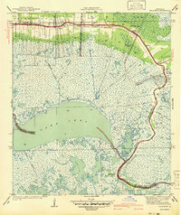 1941 Delacroix1941 Print · USGSCoastal St. Bernard Parish was a world of water and marsh during the late 1930s and early 1940s. Genealogists and local historians can trace the string of settlements along the bayou from St Bernard down to Delacroix, while mapping old waterways like the Magnolia Canal and Howards Ditch.
 - 1942 Map of St. Bernard, 1949 Print
 1942 St. Bernard1949 Print · USGSCoastal St. Bernard and Plaquemines Parishes are shown during the early 1940s, capturing the delta’s transition from rural settlements to an industrial oil and rail corridor. Researchers can trace family roots at the Delacroix Island School or locate historic sites like Chalmette National Monument and the Martello Tower.
End of results
Showing maps 1-2 of 2
Top cities near Contreras
Frequently asked questions
- What are the different types of historical maps available for Contreras?
- What is the oldest map of Contreras?
- Where can I purchase historical maps of Contreras for my home or office?
- Where can I download high-res historical maps of Contreras?
- Are there historical topographic maps available for Contreras?
- Is there historical aerial imagery available for Contreras?
- Where are historical maps of Contreras sourced from?