1990s Maps of Rycade, Louisiana
Explore 1 historic maps of Rycade from the 1990s. These maps offer a rare glimpse into what life looked like during the 1990s — showing old roads, neighborhoods, homes, and landmarks that have changed or disappeared over time.
Whether you're researching your family's past, planning a metal detecting trip, or studying how Rycade's landscape evolved across the 1990s, these high-resolution maps are a powerful tool for exploring the history of this region.
- Focus on a specific era: All maps on this page are from the 1990s, giving you a focused view of this time period.
- See what’s changed: Compare century-old streets, trails, and buildings to today's modern landscape using overlays and satellite layers.
- Research with precision: Use these maps for genealogy, historical research, land use analysis, or educational projects.
- View, download, or print: Maps are fully viewable online in high resolution, and can be downloaded or printed for your own records.
Start exploring Rycade's history through authentic maps from the 1990s. This is your window into the past.
Rycade, LA maps
(1)- 1992 Map of Cow Bayou
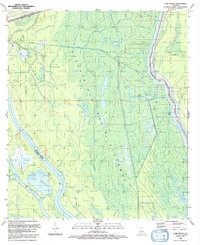 1992 Cow Bayou1992 Print · USGSThe Iberville and St. Martin Parish wetlands come alive in the early nineties, showing a landscape defined by the spillway and oil industry. Genealogists and historians can trace the intricate waterways of Billy Littles Lake, Cow Island, and the Henby Gas Field.
End of results
Showing maps 1-1 of 1
Top cities near Rycade
- New Iberia historical maps
- Henderson historical maps
- Loreauville historical maps
- Maringouin historical maps
- Rosedale historical maps
- Grosse Tete historical maps
See more
Frequently asked questions
- What are the different types of historical maps available for Rycade?
- What is the oldest map of Rycade?
- Where can I purchase historical maps of Rycade for my home or office?
- Where can I download high-res historical maps of Rycade?
- Are there historical topographic maps available for Rycade?
- Is there historical aerial imagery available for Rycade?
- Where are historical maps of Rycade sourced from?