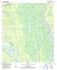
1992 Map of Cow Bayou
USGS Topo · Published 1992About this map
The Atchafalaya Basin Floodway dominates this low-lying landscape, where a dense network of bayous and lakes defines the drainage patterns of the Louisiana wetlands. In the early 1990s, the region was characterized by the intersection of natural waterways and industrial energy extraction, most notably at the Bayou des Glaises Oil and Gas Field and the Henby Gas Field. The map illustrates the complex hydrology of the basin, showing the Atchafalaya Basin Floodway Main Pilot Channel alongside more traditional water bodies like Bayou Bouillon and Billy Littles Lake. Navigational landmarks such as Pats Throat and Cow Island provide essential points of reference in an area defined by winding channels like Bayou Maringouin and Bayou La Rompe. The boundary between Iberville Parish and St Martin Parish cuts through this swampy terrain, highlighting the administrative divisions within the floodway.
Find a feature on this map
31 named features on this map. Tap any name to fly to it.
Don’t see what you’re looking for? This feature index may not catch every label — zoom into the map to look around manually.
Map Details
Editions of this 1992 Cow Bayou Map
This is the sole edition of this map. No revisions or reprints were ever made.
Other maps of this area

1935 · Osca Bayou
USGS Topo · 1:62,500

1935 · Chicot Lake
USGS Topo · 1:62,500

1940 · Grosse Tete
USGS Topo · 1:62,500

1941 · Loreauville
USGS Topo · 1:62,500

1953 · Cow Bayou
USGS Topo · 1:24,000

1953 · Pigeon Bay
USGS Topo · 1:24,000

1953 · Maringouin
USGS Topo · 1:24,000

1953 · Grosse Tete SW
USGS Topo · 1:24,000

1954 · Chicot Lake
USGS Topo · 1:62,500

1954 · Loreauville
USGS Topo · 1:62,500