1990s Maps of Kellogg, Louisiana
Explore 2 historic maps of Kellogg from the 1990s. These maps offer a rare glimpse into what life looked like during the 1990s — showing old roads, neighborhoods, homes, and landmarks that have changed or disappeared over time.
Whether you're researching your family's past, planning a metal detecting trip, or studying how Kellogg's landscape evolved across the 1990s, these high-resolution maps are a powerful tool for exploring the history of this region.
- Focus on a specific era: All maps on this page are from the 1990s, giving you a focused view of this time period.
- See what’s changed: Compare century-old streets, trails, and buildings to today's modern landscape using overlays and satellite layers.
- Research with precision: Use these maps for genealogy, historical research, land use analysis, or educational projects.
- View, download, or print: Maps are fully viewable online in high resolution, and can be downloaded or printed for your own records.
Start exploring Kellogg's history through authentic maps from the 1990s. This is your window into the past.
Kellogg, LA maps
(2)- 1992 Map of Luling
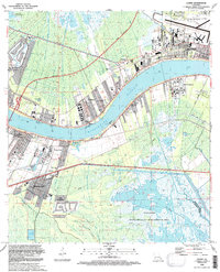 1992 Luling1992 Print · USGSSt. Charles Parish in the early nineties shows the dense riverfront settlements and industrial infrastructure lining the Mississippi. Researchers can locate the historic Davis Plantation, the site of the Davis Crevasse (1884), and St Charles Cem.
 - 1998 Map of Luling, 2000 Print
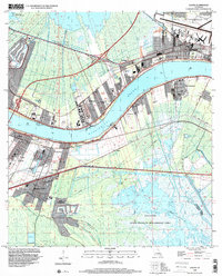 1998 Luling2000 Print · USGSSt. Charles Parish communities along the Mississippi River are shown here at the turn of the millennium. Researchers can trace land use from the Davis Plantation and Lone Star settlements to landmarks like the Davis Crevasse (1884).
End of results
Showing maps 1-2 of 2
Top cities near Kellogg
- New Orleans historical maps
- Metairie historical maps
- Kenner historical maps
- LaPlace historical maps
- Waggaman historical maps
- Westwego historical maps
See more
Frequently asked questions
- What are the different types of historical maps available for Kellogg?
- What is the oldest map of Kellogg?
- Where can I purchase historical maps of Kellogg for my home or office?
- Where can I download high-res historical maps of Kellogg?
- Are there historical topographic maps available for Kellogg?
- Is there historical aerial imagery available for Kellogg?
- Where are historical maps of Kellogg sourced from?