1930s Maps of Killona, Louisiana
Explore 2 historic maps of Killona from the 1930s. These maps offer a rare glimpse into what life looked like during the 1930s — showing old roads, neighborhoods, homes, and landmarks that have changed or disappeared over time.
Whether you're researching your family's past, planning a metal detecting trip, or studying how Killona's landscape evolved across the 1930s, these high-resolution maps are a powerful tool for exploring the history of this region.
- Focus on a specific era: All maps on this page are from the 1930s, giving you a focused view of this time period.
- See what’s changed: Compare century-old streets, trails, and buildings to today's modern landscape using overlays and satellite layers.
- Research with precision: Use these maps for genealogy, historical research, land use analysis, or educational projects.
- View, download, or print: Maps are fully viewable online in high resolution, and can be downloaded or printed for your own records.
Start exploring Killona's history through authentic maps from the 1930s. This is your window into the past.
Killona, LA maps
(2)- 1935 Map of Laplace
 1935 Laplace1935 Print · USGSSt. John the Baptist Parish and St. Charles Parish appear here in the mid-1930s during the early years of the massive Bonnet Carre Spillway project. Genealogists can locate riverfront landmarks like Trinity Plantation and early settlements including Frenier and Lucy.
 - 1936 Map of Bonnet Carre, 1937 Print
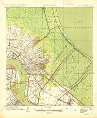
 1936 Bonnet Carre1937 Print · USGSThe Louisiana river parishes are shown in transition during the 1930s as massive flood control projects reshape the landscape. Genealogists and researchers can trace the historic Woodland Plantation, locate the Killona Sch, or study the footprints of rail-side towns like Frenier and Laplace.
End of results
Showing maps 1-2 of 2
Top cities near Killona
Frequently asked questions
- What are the different types of historical maps available for Killona?
- What is the oldest map of Killona?
- Where can I purchase historical maps of Killona for my home or office?
- Where can I download high-res historical maps of Killona?
- Are there historical topographic maps available for Killona?
- Is there historical aerial imagery available for Killona?
- Where are historical maps of Killona sourced from?