1930s Maps of Mimosa Park, Louisiana
Explore 3 historic maps of Mimosa Park from the 1930s. These maps offer a rare glimpse into what life looked like during the 1930s — showing old roads, neighborhoods, homes, and landmarks that have changed or disappeared over time.
Whether you're researching your family's past, planning a metal detecting trip, or studying how Mimosa Park's landscape evolved across the 1930s, these high-resolution maps are a powerful tool for exploring the history of this region.
- Focus on a specific era: All maps on this page are from the 1930s, giving you a focused view of this time period.
- See what’s changed: Compare century-old streets, trails, and buildings to today's modern landscape using overlays and satellite layers.
- Research with precision: Use these maps for genealogy, historical research, land use analysis, or educational projects.
- View, download, or print: Maps are fully viewable online in high resolution, and can be downloaded or printed for your own records.
Start exploring Mimosa Park's history through authentic maps from the 1930s. This is your window into the past.
Mimosa Park, LA maps
(3)- 1932 Map of Hahnville NE
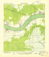 1932 Hahnville NE1932 Print · USGSSt. Charles Parish and Jefferson Parish are mapped here in the early thirties as new highways began to parallel the river's path. Researchers can trace the riverfront rail economy and local landmarks like the Kenner Ferry Landing, Lone Star, and the Outfall Canal.
 - 1935 Map of Luling
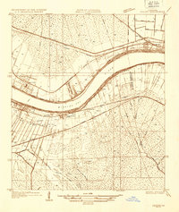 1935 Luling1935 Print · USGSSt. Charles Parish in the mid-1930s shows a landscape of riverfront settlements and vast wetlands managed by an intricate system of canals. Researchers can trace early railroad corridors and local landmarks like Lone Star, Ama, and the historic Davis Crevasse of 1884.
 - 1938 Map of Luling
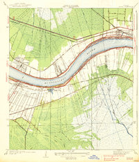 1938 Luling1938 Print · USGSThe Mississippi River corridor between Luling and Kenner is captured here in the mid-1930s, showing the early integration of the Airline Highway into the landscape. Genealogists can locate old family land tracts and settlements such as Lone Star, St Rose, and Ama, while researchers can trace the site of the historic Davis Crevasse of 1884.3 unique versions available
End of results
Showing maps 1-3 of 3
Top cities near Mimosa Park
- New Orleans historical maps
- Metairie historical maps
- Kenner historical maps
- LaPlace historical maps
- Waggaman historical maps
- Westwego historical maps
See more
Frequently asked questions
- What are the different types of historical maps available for Mimosa Park?
- What is the oldest map of Mimosa Park?
- Where can I purchase historical maps of Mimosa Park for my home or office?
- Where can I download high-res historical maps of Mimosa Park?
- Are there historical topographic maps available for Mimosa Park?
- Is there historical aerial imagery available for Mimosa Park?
- Where are historical maps of Mimosa Park sourced from?