1930s Maps of Prospect, Louisiana
Explore 2 historic maps of Prospect from the 1930s. These maps offer a rare glimpse into what life looked like during the 1930s — showing old roads, neighborhoods, homes, and landmarks that have changed or disappeared over time.
Whether you're researching your family's past, planning a metal detecting trip, or studying how Prospect's landscape evolved across the 1930s, these high-resolution maps are a powerful tool for exploring the history of this region.
- Focus on a specific era: All maps on this page are from the 1930s, giving you a focused view of this time period.
- See what’s changed: Compare century-old streets, trails, and buildings to today's modern landscape using overlays and satellite layers.
- Research with precision: Use these maps for genealogy, historical research, land use analysis, or educational projects.
- View, download, or print: Maps are fully viewable online in high resolution, and can be downloaded or printed for your own records.
Start exploring Prospect's history through authentic maps from the 1930s. This is your window into the past.
Prospect, LA maps
(2)- 1932 Map of Hahnville NW
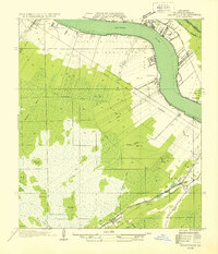 1932 Hahnville NW1932 Print · USGSSt. Charles Parish in the early thirties shows a river-driven landscape where the Mississippi River bends past Hahnville. Local historians can trace early rail lines like the Texas and Pacific or locate family tracts at Summers and Martins.
 - 1936 Map of Hahnville
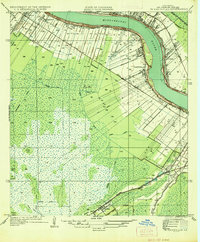 1936 Hahnville1936 Print · USGSSt. Charles Parish in the mid-1930s reveals a complex landscape of riverfront long-lots, cypress swamps, and new flood control works. Researchers can trace the early footprints of Hahnville and Boutte or locate the Mt Airy Church near the Southern Pacific Railroad.
End of results
Showing maps 1-2 of 2
Top cities near Prospect
Frequently asked questions
- What are the different types of historical maps available for Prospect?
- What is the oldest map of Prospect?
- Where can I purchase historical maps of Prospect for my home or office?
- Where can I download high-res historical maps of Prospect?
- Are there historical topographic maps available for Prospect?
- Is there historical aerial imagery available for Prospect?
- Where are historical maps of Prospect sourced from?